Penguin Bank
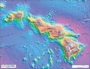
Penguin Bank is the name given to a now-submerged shield volcano of the Hawaiian Islands. Its coral-capped remains lie immediately west of the island of Molokaʻi under relatively shallow water (see bathymetric map at right). Penguin Bank was one of the seven principal volcanoes (along with West Molokaʻi, East Molokaʻi, Lānaʻi, West Maui, East Maui and Kahoʻolawe) that formerly constituted the island of Maui Nui. The volcano is part of the Hawaiian-Emperor seamount chain. The last eruption is unknown.
Plans to build wind turbines in Penguin Bank were called off in April 2009.[1]
Boundary area
Penguin Bank is about 20 miles (32 km) long and 10 miles (16 km) wide and less than 200 feet (61 m) deep.[2] The site coordinates are: NW (21°03′N 157°42′W / 21.050°N 157.700°W); NE (21°12′N 157°24′W / 21.200°N 157.400°W); SW (20°54′N 157°36′W / 20.900°N 157.600°W); and SE (21°03′N 157°21′W / 21.050°N 157.350°W).[3]
References
- ↑ Perez, Rob (21 April 2009). "Penguin Bank project called off". The Honolulu Advertiser. Retrieved 26 October 2012.
- ↑ "Project Site: Penguin Bank, Hawaii". Grays Harbor Ocean Energy Company. Retrieved 26 October 2012.
- ↑ "Gridded bathymetry of Penguin Bank, Hawaii, USA". University of Hawaiʻi at Mānoa. 14 November 2011. Retrieved 26 October 2012.
| ||||||||||||||||||||