Pen y Fan
| Pen y Fan | |
|---|---|
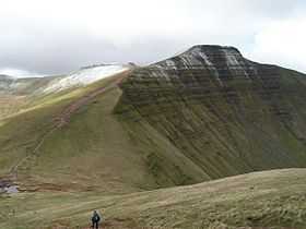 Pen y Fan from Cribyn | |
| Elevation | 886 m (2,907 ft) |
| Prominence | 668 m (2,192 ft) |
| Parent peak | Snowdon |
| Listing | Marilyn, Hewitt, Council top, Nuttall |
| Translation | the mountain's peak (Welsh) |
| Pronunciation | Welsh: [pɛnəˈvan] |
| Location | |
|
Pen y Fan Pen y Fan in the Brecon Beacons National Park (green area) | |
| Location | Powys, UK |
| Range | Brecon Beacons |
| OS grid | SO012215 |
| Coordinates | 51°53′00″N 3°26′13″W / 51.88328°N 3.43684°WCoordinates: 51°53′00″N 3°26′13″W / 51.88328°N 3.43684°W |
| Topo map | OS Landranger 160 |
Pen y Fan /pɛn.ə.ˈvæn/ is the highest peak in South Wales, situated in the Brecon Beacons National Park. At 886 metres (2,907 ft) above sea-level, it is also the highest British peak south of Cadair Idris in Snowdonia. The twin summits of Pen y Fan and Corn Du were formerly referred to as Cadair Arthur or 'Arthur's Seat'.[1]
The summit lies on a ridge stretching from Talybont Reservoir in the east, to the A470. About 0.5 km (0.31 mi) to the south-west lies the subsidiary top of Corn Du, beyond which the terrain drops at a moderate angle to the subsidiary top of Y Gyrn then more steeply to the Storey Arms on the A470. To the east, the ridge drops steeply to the col connecting it to Cribyn, the next mountain along the ridge. From Corn Du, a gentle ridge descends south towards Merthyr Tydfil.
The mountain and surrounding area are owned by the National Trust whose work parties attempt to combat the erosion caused by the passage of thousands of feet up and down this most popular of South Wales' peaks. The mountain is used by the military as part of the selection process of the UK's Special Forces personnel. Three soldiers who died after collapsing in the field in July 2013 were believed to have been climbing the mountain (see "Fan Dance") while undergoing Special Air Service selection.[2]
| Listed summits of Pen y Fan | ||||
| Name | Grid ref | Height | Status | |
|---|---|---|---|---|
| Corn Du | SJ066318 | 873 metres (2,864 ft) | sub Hewitt, Nuttall | |
| Cribyn | SJ066318 | 795 metres (2,608 ft) | Hewitt, Nuttall | |
| Y Gyrn | SJ066318 | 619 metres (2,031 ft) | sub Hewitt, Nuttall | |
Name
The name Pen y Fan consists of the Welsh words pen ('top, head, peak, summit', etc.), y ('the') and fan, a mutated form of ban ('summit, crest, peak, beacon, hill, mountain', etc.). The same noun ban, in its plural form bannau, is found in the Welsh name for the Brecon Beacons: Bannau Brycheiniog. There is no one standard translation of Pen y Fan, but 'the mountain's peak' or 'the beacon's summit' are both possible translations.[3]
Geology.
Pen y Fan is formed from various units of the Old Red Sandstone which were laid down during the Devonian period. The lower slopes of the mountain are formed from the sandstones and mudstones of the Senni Formation whilst the upper slopes are formed from those of the Brownstones Formation. The very summit, like that of neighbouring Corn Du, is composed of hard-wearing sandstones of the Plateau Beds Formation. The beds of sandstone dip gently southwards towards the South Wales Coalfield basin.
The Brecon Beacons nurtured their own glaciers during the last ice age and both Cwm Llwch and Cwm Sere were excavated by glaciers which grew in the lee of the high ground. Llyn Cwm Llwch occupies a glacially excavated rock hollow and the lake is partly dammed by a late-glacial moraine.[4]
The mountain is the highest point within the Fforest Fawr Geopark which was established in 2005 to promote economic development, particularly sustainable tourism, based on the area's geological heritage.
Tommy Jones' Obelisk


Near the route from the Storey Arms (once a coaching inn on the Brecon to Merthyr road) to the summit is a memorial granite obelisk, with an inscription which reads: "This obelisk marks the spot where the body of Tommy Jones aged 5 was found. He lost his way between Cwm Llwch Farm and the Login on the night of August 4, 1900. After an anxious search of 29 days his remains were discovered Sept [2nd]. Erected by voluntary subscriptions. W Powell Price Mayor of Brecon 1901."
Tommy was the son of a Rhondda coal miner, and had been visiting his grandparents at the time. He died from exhaustion and hypothermia or exposure. How a small boy managed to climb so high remains a mystery.
The obelisk, a useful landmark in misty conditions, was paid for by the proceeds of a memorial fund started when the jurors at the boy’s inquest waived their fees.[5]
The search was used as the theme of the 1980 film, Tommy Jones.[6]
Panorama
From the summit on a clear day the Bristol Channel (including the islands of Flat Holm and Steep Holm), Carmarthen Bay, Swansea Bay, the Gower Peninsula, the Black Mountains, the Cambrian Mountains, Exmoor, the town of Brecon and much of Mid Wales and the South Wales Valleys, and in a north-easterly direction the Clee Hills in South Shropshire can be seen.
References
- ↑ Nuttall, John & Anne (1999). The Mountains of England & Wales - Volume 1: Wales (2nd edition ed.). Milnthorpe, Cumbria: Cicerone. ISBN 1-85284-304-7.
- ↑ http://www.dailymail.co.uk/news/article-2386886/Soldier-died-17-days-collapsing-SAS-training-exercise-Brecon-Beacons-hottest-day-year-suffered-multiple-organ-failure.html
- ↑ On the elements pen and ban, see the standard historical dictionary of the Welsh language, Geiriadur Prifysgol Cymru.
- ↑ British Geological Survey 1:50,000 map sheet 213 'Brecon' & accompanying sheet explanation
- ↑ Fuller account at http://www.breconbeacons.org/tommy-jones
- ↑ British Film Institute listing http://ftvdb.bfi.org.uk/sift/title/109226
Tenth Man Down. (novel) Author: Chris Ryan
External links
| Wikimedia Commons has media related to Pen y Fan. |
- Computer generated summit panoramas North South Index
- BBC Wales feature on the Beacons
- National Trust walking route
- www.geograph.co.uk : photos of Pen y Fan and surrounding area
- Victim of the Beacons : The Tommy Jones Story from the Brecon Beacons National Park Authority
- www.penyfanrace.org.uk : Pen y Fan Race and Brecon Fans Race Weekend
- www.mynydd-du.org.uk : Mynydd Du Mountain Runners
| ||||||||||||||||||||||||||||
