Pelican Point, Western Australia
| Pelican Point Bunbury, Western Australia | |||||||||||||
|---|---|---|---|---|---|---|---|---|---|---|---|---|---|
 | |||||||||||||
| Population | 765 (2006 Census) | ||||||||||||
| • Density | 348/km2 (901/sq mi) | ||||||||||||
| Established | 1997 | ||||||||||||
| Postcode(s) | 6230 | ||||||||||||
| Area | 2.2 km2 (0.8 sq mi) | ||||||||||||
| Location | 6 km (4 mi) from Bunbury | ||||||||||||
| LGA(s) | City of Bunbury | ||||||||||||
| State electorate(s) | Electoral district of Bunbury | ||||||||||||
| Federal Division(s) | Forrest | ||||||||||||
| |||||||||||||
Coordinates: 33°19′16″S 115°41′31″E / 33.321°S 115.692°E
Pelican Point is a northeastern suburb of Bunbury, Western Australia, adjoining Eaton six kilometre from the centre of Bunbury. Its local government area is the City of Bunbury.
History
The suburb was developed from 1997 onwards by the City of Bunbury. The Sanctuary Golf Resort was designed in 1994 by Michael Coate, and residential estates opened around it and along the surrounding waterways and wetlands.Pelican Point is now one of the wealthiest suburbs of Bunbury with house prices as high as A$2,000,000.
Geography
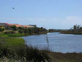
The suburb of Pelican Point is bounded to the west and south by the port railway, to the east by Old Coast Road, and otherwise by the Leschenault Estuary and the mouth of the Collie River. Only the north-eastern third is available for residential development.[1]
Facilities
Pelican Point's main attraction is the Sanctuary Golf Resort, open since 1999, with an All Seasons hotel and 18-hole golf course on site. The resort hosts a range of events. Several B&Bs, foreshore parks and a boat ramp are also located within the suburb. A neighbourhood shopping centre is proposed at the intersection of Estuary Drive and Old Coast Road. Eaton Central shopping centre meets daily shopping needs, while Bunbury Forum to the south-west provides other services. Near the suburb's eastern boundary are Eaton Community Centre and Eaton Primary School.
Transport
Pelican Point is served by the 601 (Eaton) and 701 (Australind) routes from Bunbury's central bus station, with a journey time of approximately 15 minutes. The routes are operated by Bunbury City Transit for the Public Transport Authority[2]
References
External links
- Australian Bureau of Statistics (25 October 2007). "Pelican Point (State Suburb)". 2006 Census QuickStats. Retrieved 2008-10-02.
- Pelican Point Neighbourhood Centre - City of Bunbury
- Sanctuary Golf Resort
| ||||||||||