Peaceful Village, Missouri
| Peaceful Village, Missouri | |
|---|---|
| Village | |
 Peaceful Village, Missouri | |
| Coordinates: 38°28′03″N 90°32′25″W / 38.46750°N 90.54028°WCoordinates: 38°28′03″N 90°32′25″W / 38.46750°N 90.54028°W | |
| Country | United States |
| State | Missouri |
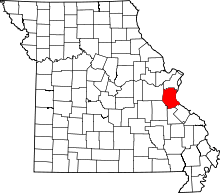
| County | Jefferson |
| Area[1] | |
| • Total | 0.17 sq mi (0.44 km2) |
| • Land | 0.17 sq mi (0.44 km2) |
| • Water | 0 sq mi (0 km2) |
| Elevation | 801 ft (244 m) |
| Population (2010)[2] | |
| • Total | 9 |
| • Estimate (2012[3]) | 9 |
| • Density | 52.9/sq mi (20.4/km2) |
| Time zone | Central (CST) (UTC-6) |
| • Summer (DST) | CDT (UTC-5) |
| Area code(s) | 636 |
| GNIS feature ID | 2585133[4] |
Peaceful Village (also known as Peaceful) is a village in Jefferson County, Missouri, United States.[4] As of the 2010 census, Peaceful Village has a population of 9.[5]
Geography
According to the United States Census Bureau, the village has a total area of 0.17 square miles (0.44 km2), all of it land.[1]
Demographics
2010 census
As of the census[2] of 2010, there were 9 people, 4 households, and 3 families residing in the village. The population density was 52.9 inhabitants per square mile (20.4/km2). There were 4 housing units at an average density of 23.5 per square mile (9.1/km2). The racial makeup of the village was 100.0% White.
There were 4 households of which 25.0% were married couples living together, 50.0% had a female householder with no husband present, and 25.0% were non-families. 25.0% of all households were made up of individuals and 25% had someone living alone who was 65 years of age or older. The average household size was 2.25 and the average family size was 2.33.
The median age in the village was 44.5 years. 0.0% of residents were under the age of 18; 22.2% were between the ages of 18 and 24; 33.3% were from 25 to 44; 11.1% were from 45 to 64; and 33.3% were 65 years of age or older. The gender makeup of the village was 33.3% male and 66.7% female.
References
- ↑ 1.0 1.1 "US Gazetteer files 2010". United States Census Bureau. Retrieved 2012-07-08.
- ↑ 2.0 2.1 "American FactFinder". United States Census Bureau. Retrieved 2012-07-08.
- ↑ "Population Estimates". United States Census Bureau. Retrieved 2013-05-30.
- ↑ 4.0 4.1 "Village of Peaceful Village". Geographic Names Information System. United States Geological Survey.
- ↑ "American FactFinder". U.S. Census Bureau. Retrieved 4 March 2011.
| |||||||||||||||||||||||||