Peć
| Peć | |
|---|---|
| City and municipality | |
| Albanian: Peja, Pejë Serbian: Пећ, Peć Bosnian: Peć Turkish: İpek | |
|
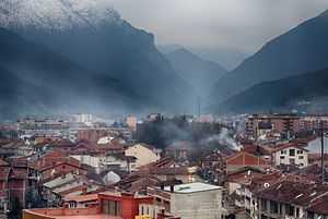
From top (left to right): Peja city center, Zenel Beg Tower (Kulla), Rugova Canyon, Ethnological Museum, Old Bazaar, Bistrica River, the Patriarchate of Peja and the train station of Peja. | |
 Peć Location in Kosovo | |
| Coordinates: 42°39′N 20°18′E / 42.650°N 20.300°E | |
| Country | Kosovo[a] |
| District | District of Peć |
| Area | |
| • City and municipality | 601 km2 (232 sq mi) |
| • Urban | 14.008 km2 (5.409 sq mi) |
| Population | |
| • City and municipality |
ca. 170,000 (municipality) ca. 82,300 (city) |
| • Density | 120/km2 (300/sq mi) |
| • Metro | 60,000 |
| As of 2009[1] | |
| Time zone | CET (UTC+1) |
| • Summer (DST) | CEST (UTC+2) |
| ZIP code | 30000 |
| Area code(s) | +381 |
| Car plates | 03 |
| Website | Municipality of Peć |

Peć or Pejë (Albanian: Peja or Pejë; Serbian: Пећ or Peć; Bosnian: Peć; Turkish: İpek) is a city in western Kosovo,[lower-alpha 1] and the administrative centre of the homonymous district. The municipality covers an area of 602 km2 (232 sq mi), including the city of Peć and 95 villages; it is divided into 28 territorial communities. As of 2011, the whole municipality has a population of approximately 95,723, of which ca. 60,000 live in the city of Peć.
Name
In Serbian, Peć means furnace or cave and its name is probably connected with nearby caves in the Rugova Canyon which served as hermit cells for Serbian Orthodox monks.[2] In medieval Ragusan documents, the Serbian name of the city (Peć, lit. "furnace") is sometimes translated as Forno, meaning furnace in Italian. During Ottoman rule, it was known as Ottoman Turkish ايپك (İpek). The Albanian name's definite form is Peja and the indefinite Pejë. Other names of the city include the Latin Pescium and Siparantum, the Greek Episkion (Επισκιον), the Ottoman Turkish ايپك (İpek), the Slavonic Petcha,[3] and the formerly used form Pentza.
Geography
Location
The city lies near the Rugova Canyon.
Administration
The municipality covers an area of 602 km2 (232 sq mi), including the city of Peć and 95 villages; it is divided into 28 territorial communities.[4] As of 2011, the whole municipality has a population of approximately 95,723,[4] of which ca. 60,000 live in the city of Peć.[5]
Climate
| Climate data for Peć (1961-1990) | |||||||||||||
|---|---|---|---|---|---|---|---|---|---|---|---|---|---|
| Month | Jan | Feb | Mar | Apr | May | Jun | Jul | Aug | Sep | Oct | Nov | Dec | Year |
| Record high °C (°F) | 15.4 (59.7) |
22.6 (72.7) |
25.0 (77) |
28.0 (82.4) |
31.5 (88.7) |
35.8 (96.4) |
38.2 (100.8) |
35.9 (96.6) |
34.1 (93.4) |
28.3 (82.9) |
22.9 (73.2) |
18.9 (66) |
38.2 (100.8) |
| Average high °C (°F) | 2.8 (37) |
6.0 (42.8) |
10.9 (51.6) |
16.1 (61) |
20.9 (69.6) |
24.1 (75.4) |
26.5 (79.7) |
26.4 (79.5) |
22.7 (72.9) |
16.9 (62.4) |
10.1 (50.2) |
4.5 (40.1) |
15.7 (60.3) |
| Daily mean °C (°F) | −0.5 (31.1) |
2.1 (35.8) |
6.4 (43.5) |
11.2 (52.2) |
15.9 (60.6) |
19.0 (66.2) |
21.1 (70) |
20.8 (69.4) |
17.2 (63) |
11.8 (53.2) |
5.9 (42.6) |
1.2 (34.2) |
11.1 (52) |
| Average low °C (°F) | −3.6 (25.5) |
−1.5 (29.3) |
2.0 (35.6) |
6.1 (43) |
10.3 (50.5) |
13.3 (55.9) |
15.0 (59) |
14.8 (58.6) |
11.5 (52.7) |
6.8 (44.2) |
2.3 (36.1) |
−1.8 (28.8) |
6.3 (43.3) |
| Record low °C (°F) | −24.8 (−12.6) |
−19.3 (−2.7) |
−13.6 (7.5) |
−3.8 (25.2) |
0.6 (33.1) |
3.5 (38.3) |
6.7 (44.1) |
5.2 (41.4) |
−1.2 (29.8) |
−4.8 (23.4) |
−15.3 (4.5) |
−15.2 (4.6) |
−24.8 (−12.6) |
| Average precipitation mm (inches) | 85.9 (3.382) |
71.5 (2.815) |
65.2 (2.567) |
67.2 (2.646) |
68.2 (2.685) |
53.0 (2.087) |
54.7 (2.154) |
48.0 (1.89) |
52.1 (2.051) |
75.3 (2.965) |
118.2 (4.654) |
91.4 (3.598) |
850.7 (33.492) |
| Avg. precipitation days (≥ 0.1 mm) | 12.0 | 12.3 | 11.3 | 11.5 | 13.0 | 13.2 | 9.9 | 8.7 | 8.1 | 9.5 | 12.3 | 13.3 | 135.1 |
| Average relative humidity (%) | 81 | 75 | 68 | 63 | 64 | 64 | 60 | 60 | 67 | 73 | 81 | 83 | 70 |
| Mean monthly sunshine hours | 69.5 | 93.3 | 143.0 | 172.0 | 207.8 | 257.7 | 274.3 | 264.9 | 206.3 | 152.6 | 86.8 | 55.3 | 1,983.5 |
| Source: Republic Hydrometeorological Service of Serbia[6] | |||||||||||||
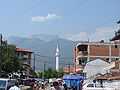
Rugova Mountains
Rugova is a mountain region located in the North-West of the city of Peć. It is the third region of “Bjeshkët e Nemuna” (The Cursed Mountains), also known as The Albanian Alps. In 2013 it was announced as a National Park by the Parliament of Republic of Kosovo.
Rugova is an ethnographic region,[7] with a great importance for the literary branches such as lexicology, etymology and onomastics. Rugova is a suitable region for hiking, skiing, mountaineering, paragliding, picnics, etc.
It was ranked as the fourth most important center for winter sports by the International Ski Federation (ISF) with the base in Lucerne. Furthermore, in April 2013, Peć won the award of “Tourism for Tomorrow” for the project “Peaks of the Balkans”.[8]
Rugova is rich with many landform elements such as caves, waterfalls, glacial lakes, high peaks, tunnels, etc. The highest peak is Hajla (2403 m), however "Qafa e Qyqes" (Cuchoo's Neck) also has an equal importance, because one can observe the whole city of Peć from it. From Guri i Kuq (1522 m) we can also observe places such as: Gjeravica, Boriqe (Three border region), Maja e Mariashit (Peak of Mariashi), Maja e Hekurave (Iron Peak), Shkëlzeni and the lake of Plava. Volujaku is also a high peak (2014 m).
History
Ancient and medieval history
The city is located in a strategic position on the Pećka Bistrica river, a tributary of the White Drin to the east of the Prokletije. The medieval city was possibly built on the ruins of Siparant(um), a Roman municipium (town or city).[9] It was mentioned by Ptolemy in his Geography as Siparantum.

Between 1180 and 1190, Serbian Grand Prince Stefan Nemanja conquered Peć with its surrounding župa (district) of Hvosno from the Byzantine Empire, thus establishing Serbian rule over the city of Peć for next 300 years.[10] The Kosovo region had long been a frontier region between the Serbs and Byzantines. In 1220, Serbian King Stefan Nemanjić donated Peć and several surrounding villages to his newly founded monastery of Žiča.[11] As Žiča was the seat of a Serbian archbishop, Peć came under direct rule of Serbian archbishops and later patriarchs who built their residences and numerous churches in the city starting with the church of Holy Apostles built by archbishop Saint Arsenije I Sremac. After the Žiča monastery was burned by the Cumans (between 1276 and 1292) the seat of Serbian archbishop was transferred to a more secure location in Peć where it remained until the abolition of the Serbian Patriarchate in 1766.
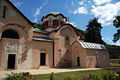
The city became a major religious center of medieval Serbia under the Serbian Emperor Stefan Dušan, who made it the seat of the Serbian Orthodox Church in 1346. It retained this status until 1766, when the Patriarchate of Peć was abolished. Today, Peć holds the Patriarchate of Serbia. The city and its surrounding area are still revered by adherents of Serbian Orthodoxy; the city is the site of the patriarchal monastery, which stands above the city and consists of four fresco-decorated churches, a library, and a treasury. The 14th century Visoki Dečani monastery, a UNESCO World Heritage Site, lies about 19 km (12 mi) south, in nearby Dečani.
Ottoman era

Peć was captured by the Ottomans in 1455,[12] and underwent major changes under their rule, including a change of name to Ipek. After the Ottoman Empire captured Peć the Sanjak of İpek was established with Mahmut Pasha Dukagjini as its first sanjakbey (lord).[13] The Sanjak of Dukagjin had four kazas: Peć, Gjakova, Gusinje and Berane.[14] The city was settled by a large number of Turks, many of whose descendants still live in the area, and took on a distinctly oriental character with narrow streets and old-style Turkish houses. It also gained an Islamic character with the construction of a number of mosques, many of which still remain. One of these is the Bajrakli Mosque, built by the Ottomans in the 15th century and located in the center of the city.
The city increased its political importance through the League of Peja, established in 1899 by Albanian patriots led by Haxhi Zeka. The League inherited the traditions and character of the League of Prizren to defend the rights of the Albanians and give them autonomous status within the Ottoman Empire. After an armed conflict with the Ottoman forces in 1900 the League ended its operations.[15]
Contemporary
Ottoman rule came to an end in the First Balkan War of 1912-13, when Montenegro took control of the city. In the late 1915, during World War I, Austria-Hungary took the city. Peć was retaken in October 1918. After World War I, the city became part of Yugoslavia (at first officially called the Kingdom of Serbs, Croats and Slovenes). Between 1931 and 1941 the city was part of Zeta Banovina. During the World War II Peć was occupied by Albania. After the war, Peć again became part of Yugoslavia as part of Kosovo and Metohija, an autonomous province within the People's Republic of Serbia.
Relations between Serbs and Albanians, who were the majority population, were often tense during the 20th century. They came to a head in the Kosovo War of 1999, during which the city suffered heavy damage and mass killings.[16] More than 80 percent of the total 5280 houses in the city were heavily damaged (1590) or destroyed (2774).[17] It suffered further damage in violent inter-ethnic unrest in 2004.
Economy
The economy was inevitably badly affected by the war, but historically it has centered on agricultural activities and craftworks produced by the city's traditional craftsmen—coppersmiths, goldsmiths, slipper makers, leather tanners, saddle makers, etc.
Kosovo Railways serve Peć railway station.
Education
Education in Peć is a system with no tuition fees, mandatory for all children between the ages of 6-18. It consists of a nine-year basic comprehensive school (starting at age six and ending at the age of fifteen) secondary general and professional education commonly known as high school and higher education at Haxhi Zeka University of Peć. It also includes non-mandatory daycare programmes for babies and toddlers and a one-year "preschool". The school year runs from early September to late June of the following year. Winter break runs from late December to early January, dividing the school year into two semesters. Peć is the only city in Kosovo that offers high school education in arts and there is a school for the visually impaired.
Culture
Architecture
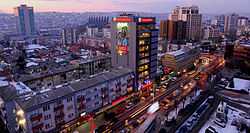
%2C_Pej%C3%AB_4.jpg)
The architecture in Peć show different architectural cultures, such as medieval Serbian, Ottoman, Yugoslav, and contemporary architecture. Because of this there are many churches, mosques, buildings which are attraction points in the city and were built by the aforementioned influences.
Notable architectural traits of Peć include:
- Patriarchate of Peć, 13th-century Serbian Orthodox monastery, the historical seat of the Serbian Orthodox Church. It is a World Heritage Site of Serbia, under the entry "Medieval Monuments in Kosovo". It is protected by the Kosovo Force.
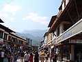
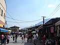
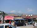
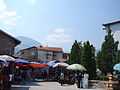
- Bazaar of Peć, Ottoman-era market in the center of the city. It was destroyed during World War II and the Kosovo War. It has been fully rebuilt.
- Bajrakli Mosque, Ottoman-built mosque in the Bazaar of Peć. It was destroyed during World War II and then rebuilt.
- Peć Hamam, Ottoman-era bath
Events and festivals
Tourism

Peć has undeveloped tourist areas such as the Rugova Canyon and Rugova Mountains. Skiing is possible in the mountains nearby. Peć Bath is a township located in the municipality of Istog, Kosovo. To many people it is known with the name Ilixhe. It is a touristic-health center with services in Istog and in the region, offering quality for inhabitation, highly developed infrastructure and every service needed for living.[18]
Sport
Peć is one of the more successful cities in Kosovan sport leagues. Its premier football team is KF Besa, its basketball teams is KB Peja. KB Peja is the older and more established basketball team. Additionally the city is host to a handball team, KH Besa Famiglia, a volleyball team KV BESA, a judo team Ippon, an athletic team Besa as well as a women's basketball team KB Penza. Since June 2008 Peć has also a Taekwondo Team: Tae Kwon Do Club Peja (Klubi i Tae Kwon Do-së Peja).[19]
Demographics
| Ethnic Composition in the municipality | |||||||||||||
| Year/Population | Albanians | % | Serbs | % | Montenegrins | % | Roma (Ashkali, Egyptians) | % | Bosniaks | % | Others | % | Total |
|---|---|---|---|---|---|---|---|---|---|---|---|---|---|
| 1961 Census | 41,532 | 62.35 | 8,852 | 13.28 | 12,701 | 19.05 | 728 | 1.09 | 1,397 | 2.1 | 66,656 | ||
| 1971 Census | 63,193 | 70.12 | 9,298 | 10.31 | 11,306 | 12.54 | 433 | 0.48 | 5,203 | 5.77 | 90,124 | ||
| 1981 Census | 79,965 | 71.99 | 7,995 | 7.2 | 9,796 | 8.82 | 3,844 | 3.46 | 8,739 | 7.86 | 111,071 | ||
| 1991 Census | 96,441 | 75.5 | 7,815 | 6.11 | 6,960 | 5.44 | 4,442 | 3.5 | 9,875 | 7.72 | 127,796 | ||
| January 1999 | ~104,600 | ~92 | n/a | n/a | n/a | n/a | ~3,500–4,000 | ~3.3 | n/a | n/a | ~4,000–4,200 | ~3.6 | ~113,000 |
| 2011 census | 87,975 | 91.2 | 332 | 0.4 | 3,836 | 3.9 | 3,786 | 3.9 | 521 | 0.5 | 96,450 | ||
| Source: Yugoslav Population Censuses for data through 1991, OSCE estimates for data from 1999, and 2011 census from Kosovo Republic.[20][21] | |||||||||||||
According to the 1981 census, the city had a population of 54,497; according to the 1991 census it had grown to 68,163.[5] In 2003 the city had a population of 81,800. According to the 2011 census, around 49,000 people live in the city of Peć.[5]
The vast majority of the inhabitants are Kosovo Albanians, but there is also a large minority community. Most Kosovo Serbs live in the village enclaves of Goraždevac, Belo Polje and Ljevoša. There is also a large Bosniak community in the city of Peć and in Vitomirica, while significant Roma, Ashkali and Egyptian communities reside in urban and rural areas.[22]
International relations
Peć is twinned with Gjilan which is also in Kosovo; Tobolsk in Russia and Nilüfer in Turkey.
Notable people
- David Albahari, Serbian author
- Mehmet Akif Ersoy, Turkish poet, who wrote the Turkish National Anthem
- Fatos Bećiraj, Albanian football player, who plays for Dinamo Zagreb and for the Montenegrin national football team
- Faruk Begolli, Albanian actor
- Qerim Begolli, signatory of the Albanian Declaration of Independence
- Vladimir Božović, Montenegrin football player
- Đorđe Božović, Serb paramilitary leader
- Agim Çavdarbasha, former Albanian sculptor
- Agim Çeku, military commander of the KLA during the 1999 Kosovo War, minister of Security Force of Kosovo
- Majlinda Kelmendi, European judo Champion for juniors
- Salih Gjuka, signatory of the Albanian Declaration of Independence
- Bedri bej Ipeku, Albanian politician
- Bogoljub Karić, Serbian politician and businessman
- Gezim Kasapolli, politician
- Rustemi Kreshnik, Albanian kickboxer
- Miodrag Krivokapić, Serbian actor
- Rahman Morina, Albanian politician
- Xhevdet Muriqi, former Albanian football player, part of the "Golden Generation" of KF Prishtina
- Fadil Muriqi, former Albanian football player, part of the "Golden Generation" of KF Prishtina
- Riza Sapunxhiu, Albanian politician
- Milutin Šoškić, former Serbian football player
- Dejan Stojanović, Serbian-Montenegrin writer
- Pavle Strugar, retired Montenegrin general in the Yugoslav People's Army (JNA)
- Sislej Xhafa, Albanian artist
- Haxhi Zeka, Albanian national leader
Gallery
-

Peć from Veljak Peak - 2014
-

Old Baazar
-

Old Mill
-

Peć from above
-

Long Baazar
-

Town center
-

Town
-
-
-
-
-

-
-
-
Notes
- ↑ Kosovo is the subject of a territorial dispute between the Republic of Serbia and the Republic of Kosovo. The latter declared independence on 17 February 2008, but Serbia continues to claim it as part of its own sovereign territory. Kosovo's independence has been recognised by 108 out of 193 United Nations member states.
References
- ↑ OSCE Mission in Kosovo: Municipal profile of Peć, March 2009. – Retrieved on 14 May 2009.
- ↑ K.Jireček, La civilisation Serbe au moyen age, Paris 1920, p.15
- ↑ 1888 "Ipek" Encyclopædia Britannica at p.211
- ↑ 4.0 4.1 OSCE Mission in Kosovo: Municipal profile of Peć, Juni 2011. – Retrieved on 14 May 2011.
- ↑ 5.0 5.1 5.2 World Gazetteer: "Kosovo: largest cities and city and statistics of their population". Archived from the original on 5 Jan 2013.. – Retrieved on 12 May 2011.
- ↑ "Monthly and annual means, maximum and minimum values of meteorological elements for the period 1961-1990" (in Serbian). Republic Hydrometeorological Service of Serbia. Retrieved 2012-11-10.
- ↑ Fjalor enciklopedik shqiptar, Tiranë, Shqipëri: Akademia e Shkencave e RPSSH, 1958, p. 9
- ↑ www.wttc.org
- ↑ Mirko Pak; Igor Vrišer (1980), Urban and industrial geography, Inštitut za geografija univerze Edvarda Kardelja v Ljubljani,
Prema tome, od gore spomenutih cinjenica mozemo pretpostaviti da je stara Pec bila municipij i da se u dardansko-rimsko doba nazivala Siparant, odnosno Slparantum.
- ↑ John V. A. Fine; John Van Antwerp Fine (1994), The Late Medieval Balkans: A Critical Survey from the Late Twelfth Century to the Ottoman Conquest, University of Michigan Press, p. 7, ISBN 0-472-08260-4
- ↑ F.Miklosich,Monumenta Serbica,Viennae 1858, p.11 at
- ↑ Prilozi za orijentalnu filologiju: Revue de philologie orientale, Volume 37. Sarajevo: Orijentalni institut u Sarajevu. 1988. p. 174. Retrieved 1 August 2011.
Poslije pada juznih dijelova Despotovine pod osmansku vlast 1455. godine, oba sjedista srpske patrijarsije, Peć i Ziča više nisu bili pod srpskom vlašću
- ↑ Altimari, Francesco; Janez Stanič (1984). Albanci (in Slovenian). Cankarjeva založba. p. 41. Retrieved 1 August 2011.
Z zavzetjem Peči je bil ustanovjjen du- kagjinski sandžak s sedežem v Peči, za sandžakbega pa postavljen Mahmut paša Dukagjini.
- ↑ Samardžić, Radovan (1983). Istorija srpskog naroda: pt. 1. Od Berlinskog kongresa do ujedinjenja 1878–1918. Srpska knjiiževna zadruga. p. 264. Retrieved 2 August 2011.
Пећки санџак је обухватао пећку, ђаковичку, гусињску и беранску (Доњи Васојевићи) казу.
- ↑ Bep Jubani et al., Historia e popullit shqiptar: për shkollat e mesme (Libri Shkollor: Pristina, 2002) 182-185.
- ↑ Crimes Of War, Time Magazine, June 28, 1999
- ↑ HRW report
- ↑ PLANI ZHVILLIMOR URBAN I SUB QENDRËS—BANJË
- ↑ tkd-peja.tk
- ↑ http://esk.rks-gov.net/rekos2011/?cid=1,92
- ↑ Mission in Kosovo: Municipal profile of Peć, March 2009. – Retrieved on 14 May 2009.
- ↑ OSCE Mission in Kosovo: Municipal profile of Peć, April 2008. – Source: Municipal Communities Officer. – Retrieved on 12 November 2008.
External links
| Wikimedia Commons has media related to Peć. |
- Municipality of Peć
- - Albanian Information - Peć
- - Serbian Information - Peć
- Municipal map of Peć Organization for Security and Co-operation in Europe, 2001
| ||||||||||||||||||||||||||||||||
| | |||||||||
|---|---|---|---|---|---|---|---|---|---|
| Rank | Name | Districts | Pop. | Rank | Name | Districts | Pop. | ||
 Pristina Prizren |
1 | Pristina | Pristina | 208,230 | 11 | Glogovac (Drenas) | Pristina | 60,687 | 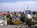 Ferizaj (Uroševac) 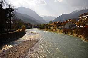 Peć |
| 2 | Prizren | Prizren | 183,810 | 12 | Lipljan | Pristina | 59,773 | ||
| 3 | Ferizaj (Uroševac) | Ferizaj (Uroševac) | 112,657 | 13 | Orahovac | Gjakova | 58,259 | ||
| 4 | Peć | Peć | 98,603 | 14 | Mališevo | Prizren | 57,136 | ||
| 5 | Gjakova | Gjakova | 97,127 | 15 | Skenderaj (Srbica) | Mitrovica | 52,175 | ||
| 6 | Gjilan | Gjilan | 92,369 | 16 | Vitina | Gjilan | 48,288 | ||
| 7 | Podujevo | Pristina | 90,568 | 17 | Deçan | Peć | 40,954 | ||
| 8 | Mitrovica | Mitrovica | 84,949 | 18 | Istok | Peć | 40,388 | ||
| 9 | Vučitrn | Mitrovica | 71,977 | 19 | Klina | Peć | 39,943 | ||
| 10 | Suva Reka | Prizren | 61,976 | 20 | Kamenica | Gjilan | 35,931 | ||