Paulo Lopes
For the Portuguese footballer, see Paulo Lopes (footballer).
| Paulo Lopes | ||
|---|---|---|
| Municipality | ||
| The Municipality of Paulo Lopes | ||
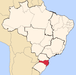
| ||
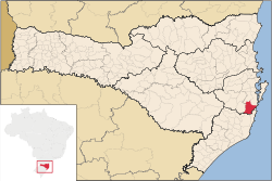 Location of Paulo Lopes in Santa Catarina state | ||
| Coordinates: 27°57′43″S 48°41′02″W / 27.96194°S 48.68389°WCoordinates: 27°57′43″S 48°41′02″W / 27.96194°S 48.68389°W | ||
| Country |
| |
| Region | South | |
| State | Santa Catarina | |
| Founded | December 21, 1961 | |
| Government | ||
| • Mayor | Evandro João dos Santos (PMDB) | |
| Area | ||
| • Total | 450.372 km2 (173.890 sq mi) | |
| Elevation | 2 m (7 ft) | |
| Population (2012) | ||
| • Total | 6,808 | |
| • Density | 15/km2 (39/sq mi) | |
| [1] | ||
| Time zone | UTC-3 (UTC-3) | |
| • Summer (DST) | UTC-2 (UTC-2) | |
| HDI (2000) | 0.759 – medium[2] | |
Paulo Lopes is a municipality in the state of Santa Catarina in the South region of Brazil.[3][4]
See also
References
- ↑ "2012 Populational Estimate". Censo Populacional 2012. Instituto Brasileiro de Geografia e Estatística (IBGE). July 2012. Retrieved September 10, 2012.
- ↑ - UNDP
- ↑ "Divisão Territorial do Brasil" (in Portuguese). Divisão Territorial do Brasil e Limites Territoriais, Instituto Brasileiro de Geografia e Estatística (IBGE). July 1, 2008. Retrieved December 17, 2009.
- ↑ "Produto Interno Bruto dos Municípios 2002-2005" (in Portuguese). Instituto Brasileiro de Geografia e Estatística (IBGE). December 19, 2007. Retrieved December 17, 2009.
| |||||||||||||||||||||||||||||||||||||||||||||||||||||||||||||||||||||||||||||||||||