Passagassawakeag River
| Passagassawakeag River | |
|---|---|
 | |
| Origin | Maine |
| Mouth |
Belfast Bay 44°25′48″N 69°00′22″W / 44.430°N 69.006°WCoordinates: 44°25′48″N 69°00′22″W / 44.430°N 69.006°W |
| Basin countries | United States |
| Source elevation | 315 feet (100 m) |
| Mouth elevation | sea level |
The Passagassawakeag River (/pæsəɡæsəˈwɑːkɛɡ/ pas-uh-gas-uh-WAH-keg or /pəˌsɑːɡæsəˈwɑːkɛɡ/ pa-SAH-ga-suh-WAH-keg) is a 16-mile-long (26 km)[1] river in Waldo County, Maine in the United States. From the outlet of Lake Passagassawakeag (44°30′04″N 69°07′59″W / 44.5012°N 69.13295°W) in Brooks, it runs south and east to its estuary in Belfast, Maine. The river empties into Belfast Bay, an inlet of Penobscot Bay, where it passes under US Route 1.
The waterway's name is of local Indian origin and is believed to mean "a sturgeon's place" or "a place for spearing sturgeon by torchlight." [2]
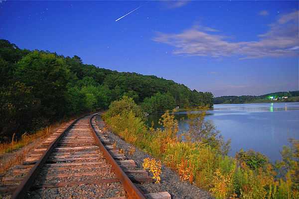
A moonlight view of the Passagassawakeag River along the tracks of the Belfast and Moosehead Lake Railroad just beyond the old Upper Bridge about two miles inland from Belfast, ME, where it empties into Belfast Bay.
References
- ↑ U.S. Geological Survey. National Hydrography Dataset high-resolution flowline data. The National Map, accessed June 22, 2011
- ↑ Fannie Hardy Eckstrom, Indian Place-Names of the Penobscot Valley and the Maine Coast; Univ of Maine Press; Orono, Maine 1974 (original 1941)
External links
| Wikimedia Commons has media related to Passagassawakeag River. |
- "Passagassawakeag River". Geographic Names Information System. United States Geological Survey. 30 September 1980. Retrieved 2010-06-17.