Pass of Drumochter


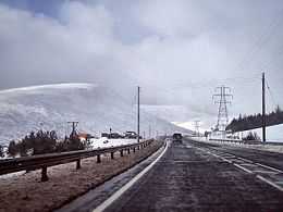
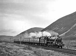
The Pass of Drumochter (Scottish Gaelic: Bealach Druim Uachdair) is the main mountain pass between the northern and southern central Scottish Highlands. The A9 road passes through here, as does the Highland Main Line, the railway between Inverness and the south of Scotland. The Sustrans National Cycle Route 7 between Glasgow and Inverness also runs through the pass.
The pass was formed by glacial action during successive Ice Ages. From this place the River Garry flows to the south, and the River Truim to the north.
The route through the pass has been used since prehistoric times. A military road built between 1728 and 1730 by General Wade came through here.
It is the high point on the A9, at 460 m (1508 ft), and in winter can be subject to severe weather conditions. There are routine winter patrols from November to March, and the road is occasionally closed with snow gates near Dalwhinnie and Dalnacardoch. The summit of the railway line is 452 m (1480 ft), making it the highest in the UK. It is used by the RAF as a main route for low level flying and Tornados and other fast jets may often be seen here.

It is isolated, and the nearest settlement of any size is the small village of Dalwhinnie, some 10 km to the north.
The summit of the pass marks the boundary between Perth and Kinross and the Highland Council area. A sign at this point says "Welcome to the Highlands/Fàilte don Ghàidhealtachd", although this is the boundary for the authority rather than for the Scottish Highlands which extend further south of here.
External links
| Wikimedia Commons has media related to Pass of Drumochter. |
References
Coordinates: 56°51′35″N 4°14′55″W / 56.85964°N 4.24856°W