Pascagoula River
The Pascagoula River is a river, about 80 miles (130 km) long, in southeastern Mississippi in the United States.[1] The river drains an area of about 8,800 square miles (23,000 km²) and flows into Mississippi Sound of the Gulf of Mexico. The Pascagoula River Basin is managed by the Pat Harrison Waterway District.[2]
It is significant as the only unaffected (or nearly so) river with a discharge of over 10 cubic kilometres (2.4 cu mi) per year flowing from the United States into the Gulf of Mexico, and indeed the only one in the Cfa Köppen climate classification zone anywhere in the world, with the nearest approaches being the Juquiá and Itajaí in southeastern Brazil[3] (The Yuan Jiang and Shinano Gawa are comparable to those Brazilian rivers but are only marginally in the Cfa zone). As a result, the Pascagoula has, in modern times, been the focus of a great deal of effort regarding its conservation[4] to prevent the construction of dams on it.
Course
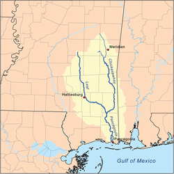
The Pascagoula River is formed in northwestern George County by the confluence of the Leaf and Chickasawhay Rivers and flows generally southward through swampy bottomlands in George and Jackson Counties. In its lower course the river forms several channels and bayous; its largest such distributary is the West Pascagoula River, which flows into the Mississippi Sound at Gautier. The main channel passes Escatawpa and Moss Point and flows into the sound at Pascagoula.
Variant names
According to the Geographic Names Information System,[5] the river has also been known as:
- East Pascagoula River (below the branching off of the West Pascagoula River)
- Fiume Pescagoula
- Pasca Oocooloo River
- Pascoboula River
- Paska Okla River
- Paspagola River
- Pasquagola River
- Rio de Pascagula
- Riviere des Pascagoula
- Riviere des Pascagoulas
- Singing River (lower 8 miles of the river)[6]
See also
- List of Mississippi rivers
- Pascagoula Abduction
References
- ↑ The Pascagoula River Basin Retrieved 2012-08-28
- ↑ Pat Harrison Waterway District Retrieved 2012-12-20
- ↑ Nilsson, C., Reidy, C. A., Dynesius, M., and Revenga, C. 2005. Fragmentation and flow regulation of the world’s large river systems. Science 308: pp. 405-408 (Supporting Material; p.13)
- ↑ The Pascagoula River: Paradise in Peril Retrieved 2012-08-28
- ↑ GNIS Detail - Pascagoula River. Accessed 2015-03-11.
- ↑
Legend of the Singing River Retrieved 2012-08-28Unavailable 2015-03-11.
Coordinates: 30°45′18″N 88°40′01″W / 30.75500°N 88.66694°W