Pasarel Island
 Topographic map of Livingston Island, Greenwich, Robert, Snow and Smith Islands. | |
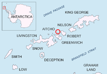 Location of Aitcho Islands in the South Shetland Islands. | |
| Geography | |
|---|---|
| Location | Antarctica |
| Coordinates | 62°23′50″S 59°46′30″W / 62.39722°S 59.77500°W |
| Archipelago | Aitcho group |
| Length | 0.45 km (0.28 mi) |
| Width | 0.26 km (0.162 mi) |
| Country | |
| Demographics | |
| Population | 0 |
| Additional information | |
| Administered under the Antarctic Treaty System | |
Pasarel Island (Bulgarian: остров Пасарел, ‘Ostrov Pasarel’ \'os-trov pa-sa-'rel\) is an ice-free island in the Aitcho group on the west side of English Strait in the South Shetland Islands, Antarctica. The island is situated 900 m (980 yd) northwest of Barrientos Island, 1.35 km (0.84 mi) northeast of Sierra Island and 650 m (710 yd) southeast of Emeline Island. Extending 450 by 260 m (490 by 280 yd). The area was visited by early 19th century sealers.
Named after the settlement of Dolni (Lower) Pasarel in western Bulgaria.
Location
Pasarel Island is located at 62°23′50″S 59°46′30″W / 62.39722°S 59.77500°W. Bulgarian mapping in 2009.
See also
- Composite Gazetteer of Antarctica
- List of Antarctic islands south of 60° S
- SCAR
- Territorial claims in Antarctica
Map
- L.L. Ivanov. Antarctica: Livingston Island and Greenwich, Robert, Snow and Smith Islands. Scale 1:120000 topographic map. Troyan: Manfred Wörner Foundation, 2010. ISBN 978-954-92032-9-5 (First edition 2009. ISBN 978-954-92032-6-4)
References
- Bulgarian Antarctic Gazetteer. Antarctic Place-names Commission. (details in Bulgarian, basic data in English)
External links
- Pasarel Island. SCAR Composite Antarctic Gazetteer.
This article includes information from the Antarctic Place-names Commission of Bulgaria which is used with permission.