Paryaqaqa mountain range
| Paryaqaqa mountain range | |
|---|---|
| Waruchiri mountain range | |
|
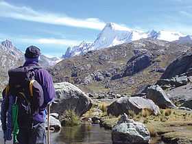
Paryaqaqa, south peak | |
| Highest point | |
| Peak | Paryaqaqa |
| Elevation | 5,750 m (18,860 ft) |
| Geography | |
| Country | Peru |
| State/Province | Junín Region, Lima Region |
| Parent range | Andes |
The Paryaqaqa mountain range (Quechua parya reddish, sparrow, qaqa rock,[1][2] Paryaqaqa or Parya Qaqa, a regional deity, a mountain god (apu),[3] hispanicized spellings Pariacaca, Pariacacca, Pariaccaca, Pariaccacca) or Waruchiri mountain range[4][2] (hispanicized Huarochirí) lies in the Andes of Peru. It is located in the Junín Region, Yauli Province, as well as in the Lima Region, Huarochirí Province and Yauyos Province.
Mountains
The highest mountain in the range is Paryaqaqa (Tulluqutu) at 5,750 metres (18,865 ft). Other notable peaks are:[5][6]
|
|
References
- ↑ César W. Astuhuamán Gonzáles, Pariacaca: un oráculo imperial andino: "Respecto al significado del nombre de la deidad, los términos Paria (rojiza) y caca (montaña), aluden a una montaña rojiza, ... ."
- ↑ 2.0 2.1 Teofilo Laime Ajacopa, Diccionario Bilingüe Iskay simipi yuyayk'ancha, La Paz, 2007 (Quechua-Spanish dictionary)
- ↑ Steven Kaplan, Indigenous Responses to Western Christianity, New York and London, 1995, p. 68-69
- ↑ Evelio Echevarría, The Cordillera Huarochiri, Peru, The Alpine Journal 2001: "Names used by mountaineers other than Huarochiri and Pariacacca are unknown to the local inhabitants and should therefore be discarded. ... The best policy is to refer to this range with either of the names in use by the local population."
- ↑ allthemountains.com Maps of the Central Andes of Peru including two maps of the Paryaqaqa mountain range (inactive website)
- ↑ escale.minedu.gob.pe - UGEL map of the Yauli Province (Junín Region) and the Huarochiri Province (Lima Region)
External links
| Wikimedia Commons has media related to Paryaqaqa. |