Park Slope
| Park Slope | |
|---|---|
| Neighborhood of Brooklyn | |
 | |
 Park Slope | |
| Coordinates: 40°40′21″N 73°58′37″W / 40.672404°N 73.977063°WCoordinates: 40°40′21″N 73°58′37″W / 40.672404°N 73.977063°W | |
| Country | United States |
| State | New York |
| City | New York City |
| Borough | Brooklyn |
| Population (2000) | |
| • Total | 65,047[1] |
| ZIP Codes | 11215, 11217 |


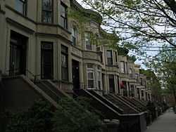
Park Slope is a neighborhood in northwest Brooklyn, New York City. Park Slope is roughly bounded by Prospect Park and Prospect Park West to the east, Fourth Avenue to the west, Flatbush Avenue to the north, and Prospect Expressway to the south. Generally, the section from Flatbush Avenue to Garfield Place (the "named streets") is considered the "North Slope", the section from 1st through 9th Streets is considered the "Center Slope", and south of 10th Street, the "South Slope".[2][3][4] The neighborhood takes its name from its location on the western slope of neighboring Prospect Park. Fifth Avenue and Seventh Avenue are its primary commercial streets, while its east-west side streets are lined with brownstones and apartment buildings.[5]
Park Slope features historic buildings, top-rated restaurants, bars, and shops, as well as proximity to Prospect Park, the Brooklyn Academy of Music, the Brooklyn Botanic Garden, the Brooklyn Museum, the Brooklyn Conservatory of Music, and the Central Library as well as the Park Slope branch of the Brooklyn Public Library system.[6] The neighborhood had a population of about 62,200 as of the 2000 census,[7] resulting in a population density of approximately 68,000/square mile, or approximately 26,000/square kilometer.
Park Slope is considered one of New York City's most desirable neighborhoods. In 2010, it was ranked number 1 in New York by New York, citing its quality public schools, dining, nightlife, shopping, access to public transit, green space, safety, and creative capital, among other aspects.[8] It was named one of the "Greatest Neighborhoods in America" by the American Planning Association in 2007, "for its architectural and historical features and its diverse mix of residents and businesses, all of which are supported and preserved by its active and involved citizenry."[9] In December 2006, Natural Home magazine named Park Slope one of America's ten best neighborhoods based on criteria including parks, green spaces and neighborhood gathering spaces; farmers' markets and community gardens; public transportation and locally owned businesses; and environmental and social policy.[10] Park Slope is part of Brooklyn Community Board 6.
History
Development
The area that today comprises the neighborhood of Park Slope was first inhabited by the Native Americans of the Lenape people. The Dutch colonized the area by the 17th century and farmed the region for more than 200 years. During the American Revolutionary War, on August 27, 1776, the Park Slope area served as the backdrop for the beginning of the Battle of Long Island. In this battle, over 10,000 British soldiers and Hessian mercenaries routed outnumbered American forces. The historic site of Battle Pass is now preserved in Prospect Park, and on Fifth Avenue there is a reconstruction of the stone farmhouse where a countercharge covered the American retreat.
In the 1850s, a local lawyer and railroad developer named Edwin Clarke Litchfield (1815–1885) purchased large tracts of what was then farmland. Through the American Civil War era, he sold off much of his land to residential developers. During the 1860s, the City of Brooklyn purchased his estate and adjoining property to complete the West Drive and the southern portion of the Long Meadow in Prospect Park.[5] However, Park Slope’s bucolic period ended soon after. By the late 1870s, with horse-drawn rail cars running to the park and the ferry, bringing many rich New Yorkers in the process, urban sprawl dramatically changed the neighborhood into a streetcar suburb. Many of the large Victorian mansions on Prospect Park West, known as the Gold Coast, were built in the 1880s and 1890s to take advantage of the beautiful park views. Today, many of these buildings are preserved within the 24-block Park Slope Historic District, one of New York's largest landmarked neighborhoods. By 1883, with the opening of the Brooklyn Bridge, Park Slope continued to boom and subsequent brick and brownstone structures pushed the neighborhood's borders farther. The 1890 census showed Park Slope to be the richest community in the United States.


In 1892, President Grover Cleveland presided over the unveiling of the Soldiers' and Sailors' Arch at Grand Army Plaza, a notable Park Slope landmark. The Park Slope Armory was completed in 1893. Nearby, Old Stone House is a 1930 reconstruction of the Vechte-Cortelyou House which was destroyed in 1897. It is located on Third Street between Fourth and Fifth Avenues, beside the former Gowanus Creek.
Baseball
Baseball had also played a prominent role in the history of the Park Slope area. From 1879 to 1889, the Brooklyn Atlantics (later to become the Dodgers) played at Washington Park on 5th Avenue between 3rd and 4th Streets. When the park was destroyed by a fire, the team moved to their part-time home in Ridgewood, Queens and then to a park in East New York. In 1898, the "New" Washington Park was built between Third and Fourth Avenues and between First and Third Streets near the Gowanus Canal. The team, by this point known as the Dodgers, played to an ever-growing fan base at this location. By the end of the 1912 season, it was clear that the team had outgrown the field, and the neighborhood. Team owner Charles Ebbets moved the team to his Ebbets Field stadium in Flatbush for the beginning of the 1913 season.[11] The team went on to have historic crosstown rivalries with both the New York Giants and New York Yankees.
1960 air collision
On December 16, 1960, two airliners collided above Staten Island, killing 135 people in what was the worst U.S. aviation disaster to date. One of the airplanes, a Douglas DC-8 operating as United Airlines Flight 826, was able to stay airborne for a few miles before crashing near the corner of Sterling Place and Seventh Avenue,[12] destroying several buildings. Everyone on board was instantly killed, except for one 11-year-old boy, Stephen Baltz, who survived the night at nearby New York Methodist Hospital before succumbing to his injuries.[13] Six people on the ground were also killed, including Wallace E. Lewis, the church's 90-year-old caretaker; Charles Cooper, a sanitation worker who was shoveling snow; Joseph Colacino and John Opperisano, who were selling Christmas trees on the sidewalk; Dr. Jacob L. Crooks, who was out walking his dog; and Albert Layer, the owner of the butcher shop located just off Seventh Avenue on Sterling Place.[14]

Decline and revitalization
By the 1950s, many of the wealthy and middle-class families fled for the suburban life and Park Slope became a rougher, more working-class neighborhood. It was mostly Italian and Irish in the 1950s and 1960s, though this changed in the 1960s and 1970s as the black and Latino population of the Slope increased and many of the Italian and Irish population began to relocate.[15] This white flight was epitomized in the 1970 film The Landlord.[16]
In the late 1960s and early 1970s, the renovation of a now-US$4.8 million brownstone along Berkeley Place[17] sparked a trend where the rest of the brownstones were cleaned up, and the grittiness of the neighborhood was removed.[18] Young professionals began to buy and renovate brownstones (which only cost around US$15,000–35,000 at the time), often converting them from rooming houses into single and two-family homes.[19] Preservationists helped secure landmark status for many of the neighborhood's blocks of historic row houses, brownstone, and Queen Anne, Renaissance Revival, and Romanesque mansions. After the 1973 creation of the landmark district, primarily above 7th Avenue, gentrification began to take off. Throughout the 1970s, the area saw an influx of young professional couples.[20]
By the early 1980s, however, even as the gentrification of the neighborhood was rapidly proceeding, crime was soaring, along with crime in the rest of New York City. It was said that there was a crack house near Prospect Park, and muggings and shootings were a daily occurrence.[21]
Gentrification accelerated during the 1980s and 1990s as working-class families were generally replaced by upper-middle-class people being priced out of Manhattan or Brooklyn Heights. The Park Slope Historic District was listed on the National Register of Historic Places in 1980.[22][23] The influx of these new upper middle class residents has made Park Slope one of the wealthiest neighborhoods in Brooklyn.[24] Sociologist and urban theorist Sharon Zukin has written of the trend, "In Park Slope, the middle class found a sense of history and a picturesque quality that fit their sense of themselves."[25] Since the mid-1990s young and childless professionals who in previous decades would most likely have lived in Manhattan have been moving to the neighborhood in ever-increasing numbers. Gentrification has also overflowed even into the surrounding areas, such as Prospect Heights to the north and Windsor Terrace to the southeast. The influx of these new upper middle class residents have made Park Slope one of the wealthiest neighborhoods in Brooklyn.[24]
A 2001 report by the New York City Rent Guidelines Board found that from 1990 to 1999, rents in Park Slope increased by 3.5–4.4% per year, depending on what kind of building the apartment was in.[26] The explosion of property values inspired real estate agents to be increasingly generous about the borders of Park Slope, not unlike the rebranding that expanded Fort Greene into Bedford-Stuyvesant; South Slope, Prospect Heights, Windsor Terrace, Gowanus, Greenwood Heights, and Boerum Hill all became to some extent part of greater Park Slope.
Transportation
The neighborhood is well-served by the New York City Subway. The IND Culver Line (F G trains) runs along Ninth Street, a main shopping street, stopping at Fourth Avenue, Seventh Avenue and 15th Street – Prospect Park/Prospect Park West. The IRT Eastern Parkway Line (2 3 4 5 trains) runs under Flatbush Avenue with an express stop at Atlantic Avenue – Barclays Center, and local stops (served by the 2 3 4 trains) at Bergen Street and Grand Army Plaza. The BMT Fourth Avenue Line's local trains (D N R trains) serve Prospect Avenue, Ninth Street, and Union Street stations, with the D N R trains all serving Atlantic Avenue – Barclays Center, an express station. The BMT Brighton Line (B Q trains) also passes through the neighborhood under Flatbush Avenue making stops at Atlantic Avenue – Barclays Center and Seventh Avenue. All three stations at Atlantic Avenue are connected to each other.[27]
Additionally, several MTA New York City Transit bus routes serve the area, including the B61, B63, B67, and B69.[28]
Community institutions
- Park Slope Food Co-op on Union Street has approximately 15,000 members from Park Slope and other neighborhoods. Only members may shop there and membership requires a work commitment of 23⁄4 hours every four weeks.
- Park Slope Volunteer Ambulance Corps provides emergency medical services to community members regardless of ability to pay.
- The Brooklyn Conservatory of Music, part of the Brooklyn Queens Conservatory of Music, is a community music school, offering music classes, ensembles and choral opportunities, and individual instrumental and vocal lessons to students from 18 months old to adults. It was founded in 1897.
- CHiPS (Park Slope Christian Help, Inc.) is a soup kitchen that serves 200-250 men and women daily. Its Frances Residency Program provides shelter and support for young homeless mothers and their infants and toddlers. It was founded in 1971.
Religious institutions


Park Slope is home to a wide variety of religious institutions, or houses of worship, including many churches and synagogues; most are historic buildings, and date back many decades.
Churches include:
- All Nations Baptist Church (Baptist)
- All Saints' Church (Episcopal)
- Church of Gethsemane (Presbyterian)
- Grace United Methodist Church of Brooklyn (Methodist)
- Memorial Baptist Church (Baptist)
- Old First Reformed Church (Reformed)
- Park Slope United Methodist Church (Methodist)
- Resurrection Coptic Catholic Chapel (Coptic)
- St Francis Xavier (Catholic)
- St John's (Episcopal)
- St Mary's (Melkite Eastern Rite Catholic)
- St Saviour's (Catholic)
- St Thomas Aquinas (Catholic)
- Trinity Grace Church (Non-Denominational)
There is a significant Jewish population in Park Slope, allowing for a number of synagogues along the religious spectrum. In addition to a number of synagogues, there is an Eruv, sponsored by members of the various communities, that surrounds Park Slope.
Synagogues include:[29]
- Park Slope Jewish Center (Conservative),[30] 14th Street and Eighth Avenue
- Congregation B'nai Jacob (Modern Orthodox),[31] 401 9th Street
- Congregation Beth Elohim (Reform),[32] 274 Garfield Place; this is the largest Reform Jewish synagogue in Brooklyn, and is also the longest running congregation.
- Congregation Kolot Chayeinu (Unaffiliated),[33] 1012 Eighth Avenue
Schools

Public schools
Public schools are operated by the New York City Department of Education. Park Slope is in two different community school districts – district 13 and district 15. The border between these two districts is Union Street from Prospect Park West to Sixth Avenue and then President Street from Fourth to Sixth Avenue; north of this border is District 13, south of this border is district 15. Students are zoned to schools for elementary school; both district 13 and district 15 place students in middle school based on the student's ranking of acceptable middle schools. The former John Jay High School is now the John Jay Educational Campus, which houses the Secondary Schools for Law, Journalism and Research.
- MS 51 (6–8) on Fifth Avenue, between Fourth and Fifth Streets.
- MS 266 (6–8) on Park Place between Sixth and Fifth Avenues.
- PS 39 (preK-5, dist. 15) on Sixth Avenue, between Seventh and Eighth Streets.[34]
- PS 107 (preK–5, dist. 15) on Eighth Avenue, between Thirteenth and Fourteenth Streets.[35]
- PS 118 (preK-5, dist.15) on Fourth Avenue, Between Seventh and Eighth Streets.
- PS 124 (preK-5, dist. 15) on Fourth Avenue, between Thirteenth and Fourteenth Streets.
- PS 133 (preK-5, dist. 13) on Fourth Avenue, between Butler and Baltic Streets.
- PS 282 (preK-5, dist. 13) on Sixth Avenue, between Berkeley Place and Lincoln Place.[36]
- PS 321 (preK-5, dist. 15) on Seventh Avenue, between First and Second Streets.[37]
- Secondary School for Law, Journalism and Research (6–12) (formerly John Jay HS), 237 Seventh Avenue between Fourth and Fifth Streets.
Private schools
- Beth Elohim Day School (preK-K) on Eighth Avenue and Garfield Place.
- Berkeley Carroll School (preK–12) on Lincoln Place, between Seventh and Eighth Avenues; Carroll Street, between Sixth and Seventh Avenues; and President Street, between Sixth and Seventh Avenues.
- Brooklyn Free School (ages 5–15) on Sixteenth Street, between Fourth and Fifth Avenues. See democratic education.
- Bishop Ford Central Catholic High School (9–12) 500 19th St.
- Chai Tots Preschool Corner of Prospect Park West and 3rd St.
- Montessori School of New York (ages 2–13) on Eighth Avenue between Carroll and President Streets. See Montessori.
- Poly Prep's Lower School (part of Poly Prep Country Day School) (PreK-4) on Prospect Park West between First and Second Streets.
- St. Francis Xavier (Catholic School) (K-8). 763 President St. between 6th & 7th Avenue.
- St. Saviour Elementary School (Catholic School) (preK-8) 8th Ave between 7th and 8th Street
- St. Saviour High School (all-girls Catholic School) (9-12) 6th Street between 8th Avenue and Prospect Park West
Notable people
Actors
- Jon Abrahams[38]
- Steve Buscemi
- David Cross
- Kathryn Erbe
- Laurence Fishburne
- Zena Grey
- Maggie Gyllenhaal
- John Hodgman
- Robin Johnson
- Terry Kinney
- Athan Maroulis
- Kelly McGillis
- Wentworth Miller
- Sarah Paulson
- Keri Russell
- Peter Sarsgaard
- Streeter Seidell
- Michael Showalter
- Patrick Stewart
- Julia Stiles
- John Turturro
- John Ventimiglia
Musicians
- Sam Altman
- Foxy Brown
- Jim Black
- Ravi Coltrane
- Jonathan Coulton
- Simone Dinnerstein
- Dave Douglas
- Mark Feldman
- Michael Hearst
- Angelique Kidjo
- Scott Klopfenstein
- Talib Kweli
- John Linnell
- Kristen Anderson-Lopez and Robert Lopez[39]
- Ingrid Michaelson
- Pumpkinhead
- Geoff Rickly
- Jay Rodriguez
- Chris Speed
- Smoosh
- Scott Tixier
- Michael Weiss
- Dan Zanes
Artists
- Janine Antoni
- Jean-Michel Basquiat
- Alex Grey
- Brett Helquist
- Paul Ramirez Jonas
- Byron Kim
- Joe Mangrum
- David Rees
- Lisa Sigal
- Joan Snyder
- Lane Twitchell
Writers
- Paul Auster
- Franco Ambriz
- Joan Bauer
- Richard Bernstein
- Peter Blauner
- Howard Bloom
- Charles Blow
- Helen Boyd
- Jhumpa Lahiri
- Arthur Bradford
- Jane Brody
- Bruce Brooks
- Rudolph Delson
- Andrea Dworkin
- Jennie Fields
- Jonathan Safran Foer
- Ben Greenman
- Pete Hamill
- Colin Harrison
- Kathryn Harrison
- Lindsey Kelk
- John Hodgman
- Siri Hustvedt
- Steven Berlin Johnson
- Norton Juster
- Jim Knipfel
- Nicole Krauss
- Jonathan Lethem
- Clifford J. Levy[40]
- Michael Patrick MacDonald
- Daisy Martinez
- Rick Moody
- Itamar Moses
- Robert Reuland
- Adam Roberts (stage name Amateur Gourmet)
- Elizabeth Royte
- Brian Selznick
- Jon Scieszka
- David Shenk
- Marilyn Singer
- Amy Sohn[41]
- Christopher Stackhouse
- John Stoltenberg
- Darin Strauss
- Ned Vizzini
- Brian Wood
- Jacqueline Woodson[42]
- William Upski Wimsatt
Politics
- Carol Bellamy
- James F. Brennan
- Hugh Carey
- Bill de Blasio
- Francis Edwin Dorn
- Patrick Gaspard
- William Jay Gaynor
- Chris Hayes
- Brad Lander
- Marty Markowitz
- Chirlane McCray
- Gene Russianoff
- Chuck Schumer
- Anthony Weiner
Scientists
Chess players
See also
- 1960 New York air disaster
- List of Brooklyn, New York neighborhoods
- Streetcar suburb
References
- ↑ "Fact Sheet". US Census Bureau. pp. Zip Code Tabulation Area 112152. Retrieved 2009-08-26.
- ↑ New York Visitors Guide, Park Slope & Prospect Heights, New York, Accessed June 23, 2009. "Boundaries, Park Slope: From 19th St. north to Flatbush Ave., From Prospect Park W. west to Fourth Ave"
- ↑ Park Slope neighborhood profile, New York, extracted from a March 10, 2003 article. Accessed September 25, 2007. "Boundaries: Stretching from Prospect Park West to Fourth Avenue, Park Place to Prospect Expressway."
- ↑ Oser, Alan N. "Rezoning, and Redefining, Park Slope", The New York Times, December 28, 2003. Accessed September 25, 2007. 'As broadly defined by brokers marketing real estate there, Park Slope is bordered by Flatbush Avenue to the north, the Prospect Expressway to the south, Prospect Park and Prospect Park West to the east, and Fourth Avenue to the west. The April rezoning actually extends west as far as Third Avenue on some blocks, and only as far as 15th Street to the south."
- ↑ 5.0 5.1 Morrone, Francis (2001). An Architectural Guidebook to Brooklyn. Salt Lake City: Gibbs Smith. pp. 347–370. ISBN 1586850474.
- ↑ Brooklyn Public Library, accessed August 17, 2006
- ↑ Oser, Alan (December 28, 2003). "Rezoning, and Redefining, Park Slope". The New York Times. Retrieved 2007-06-02.
- ↑ Nate Silver (April 11, 2010). "The Most Livable Neighborhoods in New York". New York. Retrieved 2010-08-22.
- ↑ "Park Slope Brooklyn, New York". American Planning Association. 2007. Retrieved 2010-08-22.
- ↑ "America's Best Eco-Neighborhoods", Natural Home, December 6, 2006
- ↑ Dodgers Ballparks, accessed May 27, 2006
- ↑ Nathaniel Altman (October 7, 2004). "Pillar of Fire, Recalling the Day the Sky Fell, December 16, 1960". Park Slope Reader.
- ↑ http://cityroom.blogs.nytimes.com/2010/12/16/park-slope-plane-crash-a-little-brother-remembers/
- ↑ Disaster in Fog — New York Times — December 17, 1960
- ↑ Patterson, Philana (18 October 2007). "Looking Back: How Yuppies discovered Park Slope". The Real Deal. Retrieved 10 June 2014.
- ↑ Derek John (May 12, 2011). "At BAM, 'The Landlord' Shows Park Slope Before Gentrification Took Hold". WNYC. Retrieved June 10, 2014.
- ↑ Albrecht, Leslie (19 September 2013). "Brownstone That Spurred Park Slope Gentrification For Sale For $4.8 Million". DNA Info. Retrieved 10 June 2014.
- ↑ "A "Cinderella" Story On Berkeley Place". Save the Slope. 12 October 2010. Retrieved 10 June 2014.
- ↑ Hamill, Pete (2008-09-28). "40th Anniversary - Pete Hamill Revisits His Native Brooklyn - New York Magazine". Nymag.com. Retrieved 2014-06-10.
- ↑ Jim Yardley (1998-03-14). "Park Slope, Reshaped by Money; As Rents and Prices Rise, Some Fear for Neighborhood's Soul - New York Times". New York City; Park Slope (Nyc): Nytimes.com. Retrieved 2014-06-10.
- ↑ Hymowitz, Kay S. (Fall 2011). "How Brooklyn Got Its Groove Back". City Journal. Retrieved 10 June 2014.
- ↑ "National Register Information System". National Register of Historic Places. National Park Service. 2009-03-13.
- ↑ Megan Cossey (January 16, 2005). "Replanting the Rainbow Flag". The New York Times.
- ↑ 24.0 24.1 "Park Slope returns to its roots". Courant.com. 2005-03-21. Retrieved 2014-06-10.
- ↑ Powell, Michael (Feb 21, 2010). "A Contrarian's Lament in a Blitz of Gentrification". New York Times.
- ↑ Urban Gentry, Ford Foundation Report, Spring 2003
- ↑ NYC Subway Map
- ↑ Brooklyn Bus Map
- ↑ http://www.brooklynyid.com/chabad/shabbat/eruv.htm
- ↑ http://psjc.org/
- ↑ http://www.cbjparkslope.org/
- ↑ http://congregationbethelohim.org/
- ↑ http://www.kolotchayeinu.org/
- ↑ PS 39
- ↑ PS 107
- ↑ PS 282
- ↑ PS 321
- ↑ Lee, Linda. "A NIGHT OUT AT THE: Paramount Hotel; The Pajama Game", The New York Times, May 27, 2001. Accessed November 3, 2007. "A product of St. Ann's School in Brooklyn, Mr. Abrahams, 23, had invited a batch of friends from high school to join him. He lives in North Park Slope, exactly 41 minutes from here, he said."
- ↑ Fresh Air (2014-04-10). "Songwriters Behind 'Frozen' Let Go Of The Princess Mythology". NPR. Retrieved 2014-06-10.
- ↑ Levy, Clifford J. "My Family’s Experiment in Extreme Schooling." The New York Times. September 15, 2011. 1. Retrieved on May 21, 2012.
- ↑ Steven Kurtz (2009-09-09). "At Home with Amy Sohn: A Park Slope Novel Seems a Little Too Real". New York Times. Retrieved 2012-08-17.
- ↑ "Author Chat with Jacqueline Woodson". 23 July 2003. New York Public Library. Retrieved 22 February 2014.
External links
| Wikimedia Commons has media related to Park Slope, Brooklyn. |
- Park Slope Neighborhood Profile from New York Magazine
- Park Slope architecture
- Park Slope: Where Is the Love? from New York Times
