Parawada
| Parawada పరవాడ | |
|---|---|
| Suburb | |
|
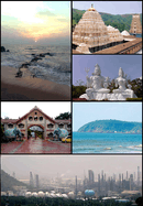
NTPC simhadri beside Ravada | |
 Parawada Location in Andhra Pradesh, India | |
| Coordinates: 17°38′00″N 83°06′00″E / 17.6333°N 83.1000°ECoordinates: 17°38′00″N 83°06′00″E / 17.6333°N 83.1000°E | |
| Country |
|
| State | Andhra Pradesh |
| District | Visakhapatnam |
| Elevation | 19 m (62 ft) |
| Languages | |
| • Official | Telugu |
| Time zone | IST (UTC+5:30) |
| PIN | 531021 |
| Vehicle registration | 31-33 |
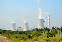
Parawada is a Suburb and a Mandal in Visakhapatnam district in the state of Andhra Pradesh in India.[1] Paravada is well developed with industries like NTPC, Jawahar nehru pharama city, New BARC and appreal park. But vastly polluting ground water and air.
Geography
Paravada is located at 17°38′00″N 83°06′00″E / 17.6333°N 83.1°E.[2] It has an average elevation of 19 meters (65 feet).
Parawada is an Mandal in Andhra Pradesh.
List of Elected Members:
- 1951 - Mullapadi Veerabhadram
- 1955 - Eti Nagayya
- 1962 - Salapu China Appala Naidu
- 1967 - S.R.S.Appala Naidu
- 1972 and 1978 - Bhattam Srirama Murthy
- 1983 and 1985 - Paila Appala Naidu
- 1989, 1994 and 1999 - Bandaru Satyanarayana Murthy
- 2004 - Gandi Babji
- 2009-Panchakarla Ramesh Babu
- 2014-Bandaru Satyanarayana Murthy
Transport
APSRTC run the buses from all areas in Visakhapatnam city. Duvvada railway station is very close to this area.
Schools
In mandal Paravada, the High School of Dharmarayudu peta is famous because they have Telugu and English medium languages. They teach well and many students got iiit seats in that school, so we want to encourage those types of schools. However, they don't have sports which we need to encourage.
References
- ↑ "List of Sub-Districts". Census of India. Retrieved 2007-03-09.
- ↑ Falling Rain Genomics.Paravada
| |||||||||||||||||||||||||||||