Papuk Geopark
The Papuk Geopark is a geopark in Croatia which is situated in two counties, Požega-Slavonia and Virovitica-Podravina, and includes upland forests of the Papuk and Krndija mountains, and edges of agricultural fields. The total area of the Geopark is 33,600 hectares (83,000 acres). In September 2007, the Papuk Geopark became the first Croatian geopark (an area with an expressed geological heritage and a strategy for a sustainable economical development) and the 30th member of the European Geoparks Network and a member of the UNESCO-assisted Global Geoparks Network.
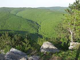
The Papuk mountains belong to the Slavonia highlands which are in Pannonia, a low-lying area of Slavonia. Even though, the Slavonia highlands are not higher than 1,000 meters, their presence is very noticeable in the landscape. This is because the surrounding alluvial fields are at around 100 m height above sea level, while the hillsides are only 100 m above the fields. The highlands are mostly covered with forests, which differentiates them from the surrounding landscape.
Within the Slavonia highlands, the Papuk Mountain stretches from west to east and is the most spacious and most interesting mountain. From the main mountain-ridge well intended are two spurs and a tract watered by a drainage basin in the direction north south. As a remarkable point, emphasis lies on peaks Točak (887 m), Papuk (953 m), Ivačka glava (913 m), Češljakovački vis (820 m), and Kapovac (792 m), which are spread out continuously, and act as a drainage divide between the numerous tributary streams flowing to the river Drava to the north, and the river Sava to the south.
See also
- List of Geoparks
- Sustainable tourism
External links
- Papuk Geopark
- Nature Park Papuk
- Papuk Geopark at the European Geoparks Network
- Global Network of National Geoparks