Papanasam, Tirunelveli
| Papanasam | |
|---|---|
| Village | |
 Papanasam Location in Tamil Nadu, India | |
| Coordinates: 8°42′43″N 77°23′35″E / 8.712°N 77.393°ECoordinates: 8°42′43″N 77°23′35″E / 8.712°N 77.393°E | |
| Country |
|
| State | Tamil Nadu |
| District | Tirunelveli |
| Languages | |
| • Official | Tamil |
| Time zone | IST (UTC+5:30) |
| PIN | 627425 |
| Vehicle registration | TN-76 |
Papanasam is a famous picnic spot in Tirunelveli district in the Indian state of Tamil Nadu. It falls under the Ambasamudram Taluk. It is situated 60 km from Tirunelveli. The site is popular with tourists attractions like Thamirabarani River, Agasthiyar falls, Siva Temple, Papanasam dam and Hydro Electric Power Plant.Pranavan also visited Papanasam.
Neighbouring towns
Vikramasingapuram and Ambasamudram are the nearby towns.
Geography
It is situated at the bank of Thamirabarani river. It is called as Thamirabarani since Copper (Thamiram in Tamil) content is maximum in the water.
Occupation
The town is surrounded by green paddy fields. It is well known for Madura coats, a fabric production company. This town is also well known for its schools. There are about 108 herbs available in the Papanasam hill area which nevery found in other part of the world.
Tourist attractions
Manjolai Hills
Located between elevations ranging from 1000 to 1500 Metres, the Manjolai area is set deep within the Western Ghats within the Kalakad Mundanthurai Tiger Reserve in the Tirunelveli District. Located on top of the Manimuthar Dam & the Manimuthar Water Falls, the Manjolai area comprises Tea Plantations, Small settlements around the tea plantations; Upper Kodaiyar Dam and a windy view point called Kuthiravetti
The Tea Plantations and the whole of Manjolai Estates are tea operated by The Bombay Burmah Trading Corporation Ltd on Forest Lands leased by the Government of Tamil Nadu. There are 3 Tea Estates within the Manjolai area - Manjolai Estate, Manimutharu Estate & Oothu Estate. The Estates are located on elevations ranging between 2300 Feet to 4200 Feet. The estates, road & the settlements in the Manjolai area are managed by The Bombay Burmah Trading Corporation Ltd. Images of Manjolai Hills can be viewed at http://www.flickr.com/photos/59865572@N00/sets/72157627351253129/
- Papanasam River (2 kilometers from Vikramasingapuram)
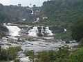
- Agasthiar Falls
- Vaana Theertham Falls
- Papanasam dam
- Papanasam (Upper) Kaarayaar Dam
- Servalar Dam
- Manimutthaar Dam
- ThaiCines - Movie Theatre (Thaai means 'Mother') (The largest movie hall of the whole district, capable of 1830 viewers)
- Kalakkad Mundanthurai Tiger Reserve [1]
Papanasar Temple
The Papanasar temple the famous shrine in Papanasam which lies in the bank of Thambaraparani river where the main deity is Lord Shiva in the name of Papanasar (Destroyer of Sins). The name of the Goddess is Lord Loganayaki who is also known as Ulagambigai.
This Papanasar temple is first among the NavaKailayams where the Navagraha known for this temple is Surya (The Sun). Papanasar is mainly known for his healing powers where he seems to be the medicine for any diseases in the world. He has the power to cure any diseases for his disciples who really have the love and affection on him.
The temple is famous for its Chittirai Peruvila where the Urchavam used to happen for 13 days. This is in memory of Saint Agasthiyar where he got the Kalyana Dharshan of Lord Shiva and Parvathy in RishabaVahana along with his wife Ulobamuthirai.
The body of Lord Papanasar is wholly and naturally made of Rudraksha who is also known as Rudrakshanathar. The old name of Papanasar is VairajaLingam.
Thiruvalluvar arts college is famous in this area.
Gallery
-
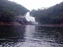
Agasthiar falls (Kalyani theertham)
-
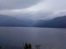
Vaana theertham falls(which flows into the Karayar dam)
-
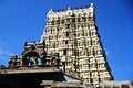
Papanasam temple (November 2007)
-
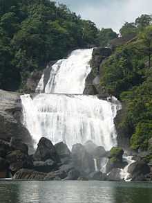
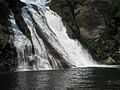
Vaana theertham falls (November 2007)
References