Papadates, Aetolia-Acarnania
| Papadates Παπαδάτες | |
|---|---|
|
Papadates | |
 Papadates | |
|
Location within the regional unit  | |
| Coordinates: 38°29′N 21°27′E / 38.483°N 21.450°ECoordinates: 38°29′N 21°27′E / 38.483°N 21.450°E | |
| Country | Greece |
| Administrative region | West Greece |
| Regional unit | Aetolia-Acarnania |
| Municipality | Agrinio |
| Government | |
| • Mayor | Pavlos Moscholios |
| • Municipal unit | 12.235 km2 (4.724 sq mi) |
| Population (2001)[1] | |
| • Municipal unit | 1,446 |
| • Municipal unit density | 120/km2 (310/sq mi) |
| Time zone | EET (UTC+2) |
| • Summer (DST) | EEST (UTC+3) |
| Postal code | 300 11 |
| Area code(s) | 26350 |
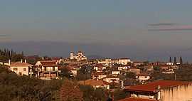
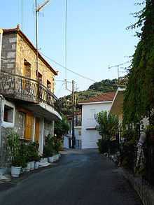
Papadates is a village in the regional unit of Aetolia-Acarnania. Situated in the region of West Greece, since 2011, it is part of the municipality of Agrinio.[2]
Papadates is located 12 klm away from the city of Agrinio, on the foothills of Arakynthos mountain and is one of the villages surrounding Lake Trichonida, the biggest Greek natural lake. It borders with the villages of Zevgaraki to the west and Mataranga to the east. It was the capital of the former municipality of Arakynthos.
The village has a population of 1,446 people (2001) and a land area of 12.235 km².
Papadates
See also
List of settlements in Aetolia-Acarnania
References
- ↑ De Facto Population of Greece Population and Housing Census of March 18th, 2001 (PDF 39 MB). National Statistical Service of Greece. 2003.
- ↑ Kallikratis law Greece Ministry of Interior (Greek)
| ||||||||||||||||||||||||||||||||||||||||||