Paola, Malta
| Paola Raħal Ġdid Pawla Casal Paola, Casal Nuovo | |||
|---|---|---|---|
| Local council | |||
| Il-Kunsill Lokali ta' Paola | |||
|
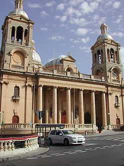
Church of Christ the King in Paola | |||
| |||
| Motto: Casal Nuovo (Casal Paola) | |||
 | |||
| Coordinates: 35°52′22″N 14°30′27″E / 35.87278°N 14.50750°ECoordinates: 35°52′22″N 14°30′27″E / 35.87278°N 14.50750°E | |||
| Country |
| ||
| Island | Malta | ||
| Borders | Cospicua, Fgura, Luqa, Marsa, Santa Luċija, Tarxien | ||
| Government | |||
| • Mayor | Roderick Spiteri (PL) | ||
| Area | |||
| • Total | 2.5 km2 (1.0 sq mi) | ||
| Population (March 2013) | |||
| • Total | 7,910 | ||
| • Density | 3,200/km2 (8,200/sq mi) | ||
| Demonym | Pawlist (m), Pawlista (f), Pawlisti (pl.), Paolites (eng.) | ||
| Time zone | CET (UTC+1) | ||
| • Summer (DST) | CEST (UTC+2) | ||
| Postal code | PLA | ||
| Dialing code | 356 | ||
| Patron saint | Christ the King; Our Lady of Lourdes | ||
| Day of festa | 4th Sunday of July; 1st Sunday after 15 August | ||


Paola (or old name Casal Nuovo) is a town in the Grand Harbour area of Malta, with a population of 7,910 people (March 2013).[1] It is named after Grandmaster Antoine de Paule who laid the foundation stone in 1626, but is commonly known as Raħal Ġdid, which means "new town" in Maltese.
Paola is renowned for the Ħal Saflieni Hypogeum, its large parish church (the largest church in the Maltese Islands), its beautiful square with shopping centres, the Good Friday procession, and its football club, Hibernians FC.
There are two parish churches, one dedicated to Christ the King and the other to Our Lady of Lourdes.
The feast of Christ the King is celebrated on the fourth Sunday of July and Our Lady of Lourdes is celebrated on the first Sunday after 17 August.
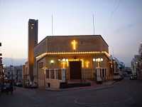
The parish also has a Franciscan church dedicated to Saint Anthony, in the Għajn Dwieli zone of the parish. St. Ubaldesca Church is the oldest church in Paola and was the first parish church there. It recently underwent restoration.
Paola also has Malta's only mosque and an Islamic Cultural Centre led by Imam Mohammed El Sadi. The country's correctional facilities and the largest burial grounds, the Addolorata Cemetery are also in this town.
The town is a commercial centre in the Southern Harbour area of Malta, about 5 km from the capital Valletta.
History
Antoine De Paule became Grandmaster of the Order of St. John on 10 March 1623, when he was 71 years old. On 20 July 1626, he set up a new town which he named "Paula" in his own honour. De Paule wanted to build a church in the town, dedicated to St. Ubaldesca, who was a sister in the Order of St. John. Pope Urbanus VIII issued the Bull which gave permission for this church to be built. This Papal Bull was issued from the Basilica of Santa Maria Maggiore in Rome on 31 July 1629. An extract from this Bull reads as follows: "we accept this request and to the afore mentioned Antonius, with the Apostolic authority granted by this Bull, we give the authority that in the mentioned town in a location of his preference, as long as it is comfortable and just, a church can be built in honour of the afore-mentioned Saint." On 12 November 1629, the Council of the Order of St. John decided to effect what was written on the Bull. The laying of the first foundation stone of this church was celebrated in grand style by Grand Master de Paule himself on Sunday 25 August 1630.
"On the day of Sunday, the 25th day of the month of August 1630, which is the feast of the king Saint Ludovico, the Most Serene and the Most Revered Grand Master Fra Antoine de Paule went to the town, which for the past four years had taken the name of his family and which was established in the land of Marsa, and he was accompanied by numerous Venerable Gran Cruci as well as by numerous brethren from our Order and in front of a crowd of people he laid the first stone of the church which was to be built for the grace of God and the Holy Virgin Ubaldesca, sister of our Religion, with the permission of the Most Reverend Prior of the church, Fra Salvatur Imbroll, who was adorned with pontifical clothes and according to the rites of the Holy Roman Church. This was done with the apolostic authority given by the Magnificent His Holiness from Santa Maria Maggiore in Rome, on the 3ist of July 1629 and which was written in the public deed of the Notary Lorenzo Grima." The church was enlarged in 1900 to accommodate the growing population of Paola and it became a parish in 1910, when it was dedicated to the Sacred Heart of Jesus. A new and larger church, the one dedicated to Christ the King, was eventually built to replace it in Antoine de Paule Square, the town's main square. Today, the church undergone restoration and its interior is adorned with beautiful gold guilding and a majestic niche holding the parish's titular statue of Christ the King.
The Hypogeum
The Hypogeum has been designated a UNESCO World Heritage Site. The Hypogeum is a labyrinthine complex of man-made chambers hewn out of the limestone extending some 11 metres below ground. It appears to have been used both as a burial site and as a temple. Neolithic man carved out the Hypogeum using only antlers and stone picks as tools, and in semi darkness. The Hypogeum is made up of three superimposed levels. The upper level resembles the earlier rock-cut tombs found elsewhere on the Islands. The middle level, hewn out during the temple period (3800 - 2500 B.C.) is made up of numerous chambers. Many statuettes, amulets, figurines and vases were recovered here. The most famous figurine is that of the so-called Sleeping Lady, a reclining figurine, perhaps meant as a representation of eternal sleep. It is on display at the National Museum of Archaeology, Valletta
Kordin Temples

Kordin I
Kordin I formed one of three sites on the high plateau overlooking the Grand Harbour. Kordin I was excavated in part by A.A. Caruana, to be continued by Sir Themistocles Zammit in 1908 and finished by T. Ashby and T.E. Peet in 1909. The building was poorly preserved and consisted of small and irregular rooms. Kordin I was left open to the elements. Air attacks during the Second World War and the building of an industrial estate on the site have obliterated all remains.
Kordin II
Kordin II was first investigated by C. Vassallo in 1840. A.A. Caruana started to excavate the site properly in 1892. The excavation was continued by Albert Mayer in 1901 and finished by Ashby and Peet in their campaign of 1908-9. The chronology was difficult to figure out, and whether all of the building could be dated to the temple period is debatable. The site must have been used during the entire temple period since pottery from all this period's phases was found during the excavations. Kordin II was damaged by the air bombardments of the Second World War and the new buildings that were constructed since.
Kordin III
The deteriorated temple is of the standard Ggantija-phase 3-apse design. It is the only temple whose forecourt, in front of the concave facade, is stone-paved, as is the entrance passage leading to the central court. Behind the temple and contemporary with it, are small rooms possibly used for storerooms or the like, or even an irregular, lobed minor temple. The most notable feature on the site is the 2.75 metre-long 'trough' lying across the entrance to the left apse. It has seven deep transverse grooves produced by grinding. It is made of hard limestone brought from over 2 kilometres away so it is highly probable that it is for grinding corn (a multiple quern) and contemporary with the temple rather than for grinding 'deffun', the traditional Maltese roofing material, which would make it considerably more recent. The site is in a walled enclosure next to the Church of St. Anthony and is kept locked to give it maximum protection.[2]
Band clubs
- Soċjeta' Filarmonika 11 ta' Frar- Madonna ta' Lourdes
- De Paule Philarmonic Society Christ the King Band (Is-Soċjetà Filarmonika De Paule Banda Kristu Re) (tal-Ħomor)
- Christ the King Band Club (Ghaqda Socjali w Muzikali Kristu Sultan Banda Paola) (tal-Ħodor)
- Lourdes Philarmonic Society A.D. 2007 (Is-Soċjetà Filarmonika Lourdes A.D. 2007)
Zones in Paola
- Għajn Dwieli
- Il-Qortin
- Kordin (Corradino)
- Moll il-Faħam
- L-Ordinanza
- Ras Ħanżir
- Tal-Borġ
- Tax-Xewk
Paola main roads
- Pjazza Antone De Paule (Paola Square)
- Telgħat Raħal Ġdid (Paola Hill)
- Triq Bormla (Cospicua Road)
- Triq Għajn Dwieli (Għajn Dwieli Road)
- Triq Ħal Luqa (Luqa Road)
- Triq Ħal Tarxien (Tarxien Road)
- Triq Ħaż-Żabbar (Żabbar Road)
- Triq il-Belt Valletta (Valletta Road)
- Triq Kordin (Corradino Hill)
- Triq l-Isqof Buhagiar (Bishop Buhagiar Street)
- Triq Sammat (Sammat Street)
- Vjal Santa Luċija (Santa Lucia Avenue)
- Vjal Sir Pawlu Boffa (Sir Paul Boffa Avenue)
- Triq Palma (Palm Str)
Notable residents
- Jason Azzopardi, Member of Parliament
- Sir Paul Boffa (1890–1962), Prime Minister, resided in this locality
- Ino Bonello, international movie art director
- Ruth Casingena, singer and actress)
- radio & TV presenter Dorian Cassar,
- Gino Cauchi (ex-member of Parliament
- Simone Cini, TV personality
- Arnold Sciberras, Naturalist
- Klinsmann Coleiro, singer
- Massimo Ellul,
- Joe Julian Farrugia, Songwriter and television producer
- Chris Fearne, paediatric surgeon and Parliamentary secretary for Health
- Carmel Joseph Farrugia (Charles Farrugia) Malta's Satellite TVRO Manufacture, Distributor,Installer and Exporter pioneer
- Immanuel Mifsud, author, winner of the European Union Prize for Literature in 2011
- Konrad Mizzi, Minister for Energy and the Conservation of Water
- Vincent Moran, ex-Minister of Health
- Silvio Parnis, Member of Parliament
- Etienne St. John, actor and TV personality
- Francesco Xuereb (founder of Our Lady of Lourdes parish and benefactor of the main parish dedicated to Christ the King)
References
- ↑ "Estimated Population by Locality" (PDF). Malta Government Gazette (19,094). 31 March 2013. Retrieved 23 January 2015.
- ↑ Columbia-Lippincott Gazeteer, 1952 Edition. p. 1425.
External links
- Christ the King Parish Church
- - Website of Paola Local Council
- G.M. Fra Antoine De Paule Philharmonic Society
- Paola - Its History and Landmarks
- RahalGdid.com- A website about the history, feast and landmarks in Paola
- RahalGdid.com - Website dwar l-istorja, l-festa u l-postijiet importanti f'Rahal Gdid
| ||||||||||||||||||||