Panteg and Griffithstown railway station
| Panteg and Griffithstown | |
|---|---|
|
Looking south showing the staggered platform layout and the line to Panteg Steel Works on the left. | |
| Location | |
| Place | Griffithstown |
| Area | Torfaen |
| Grid reference | ST294989 |
| Operations | |
| Original company | Great Western Railway |
| Pre-grouping | Great Western Railway |
| Post-grouping | Great Western Railway |
| Platforms | 2 |
| History | |
| 1 August 1880 | Opened as "Panteg" |
| 20 October 1898 | Renamed |
| 30 April 1962 | Closed to passengers |
| 3 May 1965 | Closed to goods |
| Disused railway stations in the United Kingdom | |
|
Closed railway stations in Britain A B C D–F G H–J K–L M–O P–R S T–V W–Z | |
| UK Railways portal | |

Panteg and Griffithstown railway station was a railway station which served Griffithstown near Pontypool in Torfaen, South Wales, UK.[1]
History
The station was opened by the Great Western Railway on 1 August 1880 on its line from Pontypool to Newport.[2][3] Originally known as "Panteg", it was renamed "Panteg and Griffithstown" on 20 October 1898.[2][3] The station had replaced an earlier station serving the area on the parallel Pontypool, Caerleon and Newport Railway to the east, which had opened in 1874.[2][1][3] The second station closed to passengers on 30 April 1962 and to goods on 3 May 1965.[2][3][4][5]
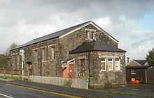
The platforms at the station were staggered and joined by a central footbridge. To the south was the goods shed, built in 18xx, and from 2002-2011 the home of the Griffithstown Railway Museum. The station was adjacent to the Panteg Steel Works, with sidings into the site. The works were also served from the Pontypool, Caerleon and Newport Railway line. To the north of the station was Coedygric Junction between the N&PR and PC&NR lines, and the southernmost part of the railway yard complex at Pontypool.
The trackbed has been redeveloped into a cycle path, and the steelworks have been demolished and replaced by housing. As of 2012, the 'up' platform and buildings remain, but in a poor state of repair.
| Preceding station | Disused railways | Following station | ||
|---|---|---|---|---|
| Blaendare Road Halt Line and station closed |
Great Western Railway Monmouthshire Railway and Canal Company |
Sebastopol Line and station closed | ||
| Pontypool Road Line closed, station open | Great Western Railway Pontypool, Caerleon and Newport Railway | |||
References
Notes
- ↑ 1.0 1.1 Conolly 2004, p. 43, section A2.
- ↑ 2.0 2.1 2.2 2.3 Quick 2009, p. 304.
- ↑ 3.0 3.1 3.2 3.3 Butt 1995, p. 180.
- ↑ Clinker 1988, p. 106.
- ↑ Haworth, Brian (24 February 2012). "Upper Pontnewydd to Pontypool". Retrieved 2013-06-01.
Sources
- Butt, R. V. J. (1995). The Directory of Railway Stations: details every public and private passenger station, halt, platform and stopping place, past and present (1st ed.). Sparkford: Patrick Stephens Ltd. ISBN 1-8526-0508-1. OCLC 60251199.
- Clinker, C.R. (1988) [1978]. Clinker's Register of Closed Passenger Stations and Goods Depots in England, Scotland and Wales 1830–1980 (2nd ed.). Bristol: Avon-Anglia Publications & Services. ISBN 0-905466-91-8. OCLC 655703233.
- Conolly, W. Philip (2004) [1958]. British Railways Pre-Grouping Atlas and Gazetteer. Hersham, Surrey: Ian Allan. ISBN 978-0-7110-0320-0.
- Quick, Michael (2009) [2001]. Railway passenger stations in Great Britain: a chronology (4th ed.). Oxford: Railway and Canal Historical Society. ISBN 978 0 901461 57 5. OCLC 612226077.
External links
Coordinates: 51°41′03″N 3°01′18″W / 51.6842°N 3.0217°W