Pangyo County
| Pangyo County 판교군 | |
|---|---|
| County | |
| Korean transcription(s) | |
| • Chosŏn'gŭl | 판교군 |
| • Hancha | 板橋郡 |
| • McCune-Reischauer | P'an'gyo kun |
| • Revised Romanization | Pangyogun |
 | |
| Country | North Korea |
| Province | Kangwon Province |
| Administrative divisions | 1 ŭp, 22 ri |
| Area | |
| • Total | 623 km2 (241 sq mi) |
| Population (1991 est.) | |
| • Total | 67,000 |
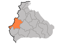
P'an'gyo County is a kun, or county, in Kangwŏn province, North Korea. In December 1952, during the Korean War, P'an'gyo was formed as a separate county from five myŏn (Nagyang, Pangjang, P'an'gyo, Ryongp'o, Sannae) of Ichŏn-gun and Yujin-myŏn of P'yŏnggang-gun. Myŏn were administrative units below county (kun) level and are no longer used in North Korea.
Physical features
The land of P'an'gyo is predominantly mountainous, with the Ahobiryŏng Mountains (아호비령산맥; 阿虎飛嶺山脈) and Masingryŏng Mountains (마식령산맥; 馬息嶺山脈) both passing through the county. The highest point is Tongbaengnyŏnsan (동백년산). The county's chief stream is the Rimjin River. Approximately 88% of the county's area is forestland.
Economy
Agriculture
Agriculture is difficult due to the rugged terrain; however, crops are raised here including maize, potatoes, soybeans, wheat, and barley. Orcharding and livestock farming also play a role.
Mining
Mining is supported by local deposits of copper and nickel.
Transport
Pankyo is served by both road and rail. Pangyo Station is on the Chongnyon Ichon Line.
See also
- Geography of North Korea
- Administrative divisions of North Korea
- Kangwon (North Korea)
External links
- (Korean) In Korean language online encyclopedias:
| ||||||||||||||||