Palting
| Palting | ||
|---|---|---|
 | ||
| ||
 Palting Location within Austria | ||
| Coordinates: 48°01′00″N 13°07′40″E / 48.01667°N 13.12778°ECoordinates: 48°01′00″N 13°07′40″E / 48.01667°N 13.12778°E | ||
| Country | Austria | |
| State | Upper Austria | |
| District | Braunau am Inn | |
| Government | ||
| • Mayor | Josef Roider (ÖVP) | |
| Area | ||
| • Total | 11 km2 (4 sq mi) | |
| Elevation | 514 m (1,686 ft) | |
| Population (1 January 2014)[1] | ||
| • Total | 915 | |
| • Density | 83/km2 (220/sq mi) | |
| Time zone | CET (UTC+1) | |
| • Summer (DST) | CEST (UTC+2) | |
| Postal code | 5163 | |
| Area code | 06217 | |
| Vehicle registration | BR | |
| Website |
www.oberoesterreich.at/ palting | |
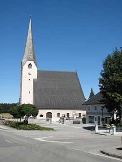
Palting is a municipality in the district of Braunau am Inn in the Austrian state of Upper Austria.
Geography
Palting lies in the Innviertel. About 18 percent of the municipality is forest and 75 percent farmland.
References
| Wikimedia Commons has media related to Palting. |