Pallabi Thana
| Pallabi পল্লবি | |
|---|---|
| Thana | |
|
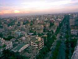
Skyline of Pallabi, Bangladesh | |
 Pallabi Location in Bangladesh | |
| Coordinates: 23°49.5′N 90°22.2′E / 23.8250°N 90.3700°ECoordinates: 23°49.5′N 90°22.2′E / 23.8250°N 90.3700°E | |
| Country |
|
| Division | Dhaka Division |
| District | Dhaka District |
| Area | |
| • Total | 17 km2 (7 sq mi) |
| Population (1991) | |
| • Total | 364,000 |
| • Density | 21,412/km2 (55,460/sq mi) |
| Time zone | BST (UTC+6) |
| Website | Official Map of the Pallabi Thana |
Pallabi (Bengali: পল্লবি) is a Thana of Dhaka District in the Division of Dhaka, Bangladesh.
Geography
Pallabi is located at 23°29′42″N 90°12′54″E / 23.495°N 90.215°E. Its total area is 17 km².
Demographics
This Pallabi has a population of 364000. Males constitute 52.74% of the population, and females 47.26%. Pallabi has an average literacy rate of 56.23%, and the national average of 32.4% literate.[1]
Administrative
Pallabi has 1 Unions/Wards, 16+27 Mauzas/Mahallas, and 0 villages.
See also
References
- ↑ "Banglapedia". Retrieved February 17, 2007.