Palekastro
| Palekastro Παλαίκαστρο | |
|---|---|
|
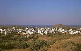
Palekastro: panorama | |
 Palekastro | |
|
Location within the region | |
| Coordinates: 35°12′N 26°15′E / 35.200°N 26.250°ECoordinates: 35°12′N 26°15′E / 35.200°N 26.250°E | |
| Country | Greece |
| Administrative region | Crete |
| Regional unit | Lasithi |
| Municipality | Siteia |
| Municipal unit | Itanos |
| Time zone | EET (UTC+2) |
| • Summer (DST) | EEST (UTC+3) |
| Website | Municipal Homepage |
Palekastro (Greek: Παλαίκαστρο; also transliterated as Palaikastro; Godart and Olivier abbreviation PK) is a small village at the east end of the Mediterranean island Crete.
It is a historic site. Already in Minoan times the region was a centre of trade. The port of Itanos, today several meters below sea level, is mentioned in ancient times. The very extensive Minoan commercial settlement Roussolakkos close to the Chiona beach, excavated by English archaeologists, clearly shows that the region was one of the most important commercial centres of the Minoan culture in the extreme east of the island of Crete. The Palaikastro Kouros is a carved figure of a youth that was recovered in fragments between 1987 and 1990.[1]
The village remains free from mass tourism. The main business of the approximately 1100 inhabitants continues to be agriculture. Olives and grape vines are cultivated and a few fisherman remain. Commercial fishing however is difficult these days because of the substantial over fishing of the Mediterranean Sea. Tourism is an important source of supplementary income and is likely to remain so.
At the east edge of the village, visible from a distance, there is a flat hill called Kastri(s). This hill gave Palekastro its name in the Middle Ages when the region was dominated by the sovereign power of Venice. On its flat summit the Venetians established a fortress. In the course of the centuries the stones were cleared away and used by the people of the region to build houses.
Trivia
- Finnish progressive rock band Kingston Wall have a song titled Palékastro on their album II.
Gallery
-

Palekastro: Main Street
-

Palekastro: the church
-

Palekastro: Kastelli Hill
-

The Minoan site of Roussolakkos
Notes
- ↑ "The Palaikastro Kouros". Retrieved 14 November 2010.
References
- Ian Swindale. "Palaikastro". Retrieved 4 February 2006.
External links
| Wikimedia Commons has media related to Palekastro. |
| ||||||||||||||
