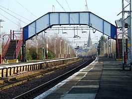
Paisley St James railway station
| Paisley Saint James | |
|---|---|
| Scottish Gaelic: Eaglais Sheumais Phàislig | |
|
St James' Church can be seen in the distance under the footbridge. | |
| Location | |
| Place | Paisley |
| Local authority | Renfrewshire |
| Coordinates | 55°51′07″N 4°26′31″W / 55.8519°N 4.4419°WCoordinates: 55°51′07″N 4°26′31″W / 55.8519°N 4.4419°W |
| Grid reference | NS472648 |
| Operations | |
| Station code | PYJ |
| Managed by | ScotRail |
| Number of platforms | 2 |
|
Live arrivals/departures, station information and onward connections from National Rail Enquiries | |
| Annual rail passenger usage* | |
| 2004/05 | 22,365 |
| 2005/06 |
|
| 2006/07 |
|
| 2007/08 |
|
| 2008/09 |
|
| 2009/10 |
|
| 2010/11 |
|
| 2011/12 |
|
| 2012/13 |
|
| 2013/14 |
|
| History | |
| 29 March 1841 | Opened |
| National Rail – UK railway stations | |
| * Annual estimated passenger usage based on sales of tickets in stated financial year(s) which end or originate at Paisley Saint James from Office of Rail Regulation statistics. Methodology may vary year on year. | |
| UK Railways portal | |
Paisley St James railway station is on the Inverclyde Line, serving a residential district of Paisley, Scotland, just west of the town centre. For passengers travelling to the commercial district, Paisley Gilmour Street is the main railway station of Paisley and is located in the heart of Paisley town centre. There is an ongoing campaign to rename the station "Paisley St Mirren" due the station's proximity to St. Mirren F.C.'s new stadium.
History
The station was opened on 29 March 1841 by the Glasgow, Paisley and Greenock Railway company.[1]
| Preceding station | |
Following station | ||
|---|---|---|---|---|
| Bishopton | ScotRail Inverclyde Line |
Paisley Gilmour Street | ||
| Historical railways | ||||
| Georgetown Line open; station closed |
Caledonian Railway Glasgow, Paisley and Greenock Railway |
Paisley Gilmour Street | ||
| Ferguslie Line and station closed |
Caledonian Railway Paisley and Barrhead District Railway |
Terminus | ||
See also
Railway Stations in Paisley | ||||||||||||||||||||||||||||||||||||||||||||||||||||||||||||||||||||||||||||||||||||||||||||||||||||||||||||||||||||||||||||||||||||||||||||||||||||||||||||||||||||||||||||||||||||||||||||||||||||||||||||||||||||||||||||
|---|---|---|---|---|---|---|---|---|---|---|---|---|---|---|---|---|---|---|---|---|---|---|---|---|---|---|---|---|---|---|---|---|---|---|---|---|---|---|---|---|---|---|---|---|---|---|---|---|---|---|---|---|---|---|---|---|---|---|---|---|---|---|---|---|---|---|---|---|---|---|---|---|---|---|---|---|---|---|---|---|---|---|---|---|---|---|---|---|---|---|---|---|---|---|---|---|---|---|---|---|---|---|---|---|---|---|---|---|---|---|---|---|---|---|---|---|---|---|---|---|---|---|---|---|---|---|---|---|---|---|---|---|---|---|---|---|---|---|---|---|---|---|---|---|---|---|---|---|---|---|---|---|---|---|---|---|---|---|---|---|---|---|---|---|---|---|---|---|---|---|---|---|---|---|---|---|---|---|---|---|---|---|---|---|---|---|---|---|---|---|---|---|---|---|---|---|---|---|---|---|---|---|---|---|---|---|---|---|---|---|---|---|---|---|---|---|---|---|---|---|
Legend
| ||||||||||||||||||||||||||||||||||||||||||||||||||||||||||||||||||||||||||||||||||||||||||||||||||||||||||||||||||||||||||||||||||||||||||||||||||||||||||||||||||||||||||||||||||||||||||||||||||||||||||||||||||||||||||||
References
Notes
Sources
- Butt, R. V. J. (1995). The Directory of Railway Stations: details every public and private passenger station, halt, platform and stopping place, past and present (1st ed.). Sparkford: Patrick Stephens Ltd. ISBN 1-8526-0508-1. OCLC 60251199.
- Jowett, Alan (March 1989). Jowett's Railway Atlas of Great Britain and Ireland: From Pre-Grouping to the Present Day (1st ed.). Sparkford: Patrick Stephens Ltd. ISBN 1-8526-0086-1. OCLC 22311137.
