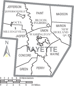
Paint Township, Fayette County, Ohio
| Paint Township, Fayette County, Ohio | |
|---|---|
| Township | |
 Municipalities and townships of Fayette County | |
| Coordinates: 39°38′13″N 83°25′46″W / 39.63694°N 83.42944°WCoordinates: 39°38′13″N 83°25′46″W / 39.63694°N 83.42944°W | |
| Country | United States |
| State | Ohio |
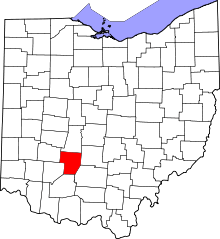
| County | Fayette |
| Area | |
| • Total | 51.7 sq mi (133.9 km2) |
| • Land | 51.7 sq mi (133.9 km2) |
| • Water | 0.0 sq mi (0.0 km2) |
| Elevation[1] | 988 ft (301 m) |
| Population (2000) | |
| • Total | 1,905 |
| • Density | 36.8/sq mi (14.2/km2) |
| Time zone | Eastern (EST) (UTC-5) |
| • Summer (DST) | EDT (UTC-4) |
| FIPS code | 39-59486[2] |
| GNIS feature ID | 1086092[1] |
Paint Township is one of the ten townships of Fayette County, Ohio, United States. The 2000 census found 1,905 people in the township, 1,031 of whom lived in the unincorporated portions of the township.[3]
Geography
Located in the northern part of the county, it borders the following townships:
- Range Township, Madison County - north
- Madison Township - east
- Marion Township - southeast
- Union Township - south
- Jefferson Township - west
- Stokes Township, Madison County - northwest
Most of the village of Bloomingburg is located in far southeastern Paint Township.
Name and history
Paint Township takes its name from the Paint Creek which flows through the township and enriches its soil.[4] It is one of six Paint Townships statewide.[5]
Government
The township is governed by a three-member board of trustees, who are elected in November of odd-numbered years to a four-year term beginning on the following January 1. Two are elected in the year after the presidential election and one is elected in the year before it. There is also an elected township fiscal officer,[6] who serves a four-year term beginning on April 1 of the year after the election, which is held in November of the year before the presidential election. Vacancies in the fiscal officership or on the board of trustees are filled by the remaining trustees.
References
- ↑ 1.0 1.1 "US Board on Geographic Names". United States Geological Survey. 2007-10-25. Retrieved 2008-01-31.
- ↑ "American FactFinder". United States Census Bureau. Retrieved 2008-01-31.
- ↑ Fayette County, Ohio — Population by Places Estimates Ohio State University, 2007. Accessed 15 May 2007.
- ↑ Allen, Frank M. (1914). "History of Fayette County, Ohio: Her People, Industries and Institutions". B. F. Bowen, Incorporated. p. 330. Retrieved 28 November 2013.
- ↑ "Detailed map of Ohio" (PDF). United States Census Bureau. 2000. Retrieved 2007-02-16.
- ↑ §503.24, §505.01, and §507.01 of the Ohio Revised Code. Accessed 4/30/2009.
External links
| |||||||||||||||||||||||||||||||||