Pagar Alam
| Pagar Alam | ||
|---|---|---|
| City | ||
| ||
| Nickname(s): "Besemah" | ||
| Motto: Besemah Kota Perjuangan (Besemah City Struggle) | ||
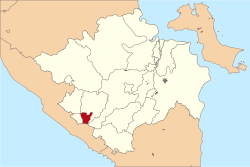 | ||
 Pagar Alam Location of the city in southern Sumatra | ||
 Pagar Alam Location of the city in Indonesia | ||
| Coordinates: 4°1′0″S 103°15′0″E / 4.01667°S 103.25000°ECoordinates: 4°1′0″S 103°15′0″E / 4.01667°S 103.25000°E | ||
| Country | Indonesia | |
| Province | South Sumatra | |
| Area | ||
| • Total | 633.66 km2 (244.66 sq mi) | |
| Population (2011) | ||
| • Total | 146,973 | |
| • Density | 224.75/km2 (582.1/sq mi) | |
| Time zone | WIB (UTC+7) | |
| Area code(s) | 0730 | |
| Website | pagaralam.go.id | |

Pagaralam is a city in South Sumatra, Indonesia. It has an area of 633.66 km²[1] and a population of 118,904 (2003).
Pagaralam is bounded by Bengkulu Province to the south, the district of Jarai to the north, the district of Kota Agung to the east and the district of Tanjung Sakti to the west.
Development
Pagaralam administration will build integrated tourism area in a 26 hectares bamboo forest at Curup Jahe in North Pagaralam district. The location is nears Curup Mangkok waterfall.[2]
Atung Bungsu Airport
Atung Bungsu Airport is the only airport in Pagar Alam. It is opened on 28 February 2013.[3]
References
External links
- (Indonesian) Official website
| |||||||||||||||||