Oyama, Tochigi
| Oyama 小山市 | ||
|---|---|---|
| City | ||
| ||
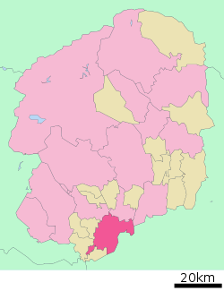 Location of Oyama in Tochigi Prefecture | ||
 Oyama Location in Japan | ||
| Coordinates: 36°19′N 139°48′E / 36.317°N 139.800°ECoordinates: 36°19′N 139°48′E / 36.317°N 139.800°E | ||
| Country | Japan | |
| Region | Kantō | |
| Prefecture | Tochigi Prefecture | |
| Government | ||
| • Mayor | Toshio Okubo (since July 2000) | |
| Area | ||
| • Total | 171.61 km2 (66.26 sq mi) | |
| Population (April 1, 2011) | ||
| • Total | 163,954 | |
| • Density | 955.39/km2 (2,474.4/sq mi) | |
| Time zone | Japan Standard Time (UTC+9) | |
| Symbols | ||
| - Tree | Quercus myrsinaefolia | |
| - Flower | Omoigawazakura (Prunus x subhirtella) | |
| - Bird | Japanese Wagtail | |
| Address |
1-1-1 Chūō-chō, Oyama-shi, Tochigi-ken 323-8686 | |
| Phone number | 0285-23-1111 | |
| Website | Oyama City | |

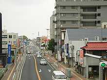
Oyama (小山市 Oyama-shi) is a city located in Tochigi Prefecture, Japan.
On April 1, 2011, the city had an estimated population of 163,954, with 62,714 households, and a population density of 955.39 persons per km². The total area is 171.61 km².
In 2006, Oyama became the second most populous city in the Tochigi Prefecture, with the capital of the prefecture Utsunomiya retaining the number one spot. The city is centred on Omoigawa River. Oyama was elevated to city status on March 31, 1954. The mayor of Oyama is Toshio Okubo. One of the major employers in the city is Komatsu making iron castings, diesel engines, fork lift trucks and other hydraulic equipment.
Oyama formally signed a sister-city agreement with Lübz, Germany in 2003 and with Cairns, Australia on May 15, 2006.
Sister cities
External links
![]() Media related to Oyama, Tochigi at Wikimedia Commons
Media related to Oyama, Tochigi at Wikimedia Commons
- Oyama City official website (Japanese)