Oxnard Transportation Center
Oxnard Transit Center | |||||||||||||||||||||||||||
|---|---|---|---|---|---|---|---|---|---|---|---|---|---|---|---|---|---|---|---|---|---|---|---|---|---|---|---|
|
Amtrak station Metrolink commuter rail station | |||||||||||||||||||||||||||
|
| |||||||||||||||||||||||||||
| Location |
201 East Fourth Street Oxnard, California 93030 US | ||||||||||||||||||||||||||
| Coordinates | 34°11′55″N 119°10′28″W / 34.198688°N 119.174538°WCoordinates: 34°11′55″N 119°10′28″W / 34.198688°N 119.174538°W | ||||||||||||||||||||||||||
| Owned by | City of Oxnard | ||||||||||||||||||||||||||
| Line(s) |
Amtrak: Metrolink: | ||||||||||||||||||||||||||
| Platforms | 1 side platform | ||||||||||||||||||||||||||
| Tracks | 2 | ||||||||||||||||||||||||||
| Connections | Greyhound bus service, VISTA (intercity bus service), Gold Coast Transit (local bus service) | ||||||||||||||||||||||||||
| Construction | |||||||||||||||||||||||||||
| Structure type | at-grade | ||||||||||||||||||||||||||
| Parking | Yes | ||||||||||||||||||||||||||
| Disabled access | Yes | ||||||||||||||||||||||||||
| Other information | |||||||||||||||||||||||||||
| Station code | OXN | ||||||||||||||||||||||||||
| History | |||||||||||||||||||||||||||
| Opened | 1987 | ||||||||||||||||||||||||||
| Traffic | |||||||||||||||||||||||||||
| Passengers (2013) |
79,136[1] | ||||||||||||||||||||||||||
| Services | |||||||||||||||||||||||||||
| |||||||||||||||||||||||||||
| Location | |||||||||||||||||||||||||||
 Location within California | |||||||||||||||||||||||||||
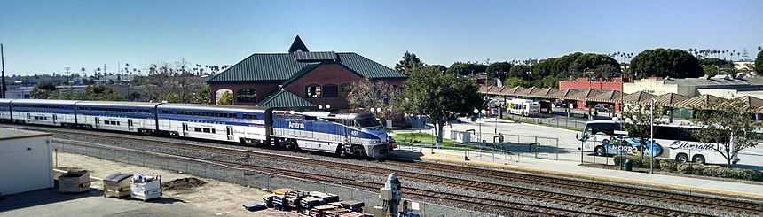
The Oxnard Transit Center, originally know as the Oxnard Transportation Center, is an Amtrak and Metrolink rail station in historic downtown Oxnard, California. This station also serves local and regional bus routes. Amtrak's Pacific Surfliner from San Luis Obispo to San Diego, Amtrak's Coast Starlight from Los Angeles Union Station to Seattle, Washington, and Metrolink's Ventura County Line from Los Angeles Union Station to East Ventura stop here. Ten Pacific Surfliner trains serve the station daily, and six Metrolink trains serve the station each weekday. The Coast Starlight operates one train daily in each direction.[2]
Of the 74 California stations served by Amtrak, Oxnard was the 28th-busiest in FY2012, boarding or detraining an average of approximately 223 passengers daily.[3]
Platforms and tracks
| East track | ■Bypass/Freight track | No regular service |
| West track | ■Coast Starlight | toward Seattle (Santa Barbara) |
| ■Coast Starlight | toward Los Angeles (Simi Valley) | |
| ■Pacific Surfliner | toward San Luis Obispo (Ventura) | |
| ■Pacific Surfliner | toward San Diego-Union Station (Camarillo or Simi Valley) | |
| ■Ventura County Line | toward East Ventura (Terminus) | |
| ■Ventura County Line | toward L.A. Union Station (Camarillo) |
Transit Connections
Gold Coast Transit
1A/B - Oxnard - Port Hueneme
2 - Colonia
3 - Oxnard - Naval Base
4A/B - North Oxnard
5 - Seabridge
6 - Oxnard - Ventura
8 - Centerpoint Mall, via Oxnard College
19/20 - Central Oxnard
VISTA
Conejo Connection - Oxnard - Camarillo - Thousand Oaks - Warner Center Transit Hub
Location and surrounding area
Historic Location
The Southern Pacific Railroad constructed a spur at Montalvo in late 1897 on the original route connecting Ventura to Los Angeles through the Santa Clara River Valley. This spur was needed for shipping construction equipment to the site of a new beet sugar refinery. A wooden railroad trestle and rail line were constructed over the Santa Clara River as the spur headed south, reaching the new settlement here on the relatively isolated coastal plain in April 1898.[4] The rail line turned here from the north-south alignment to east-west as they continued building the tracks to Santa Susana in the Simi Valley. With the completion of the Santa Susana Tunnel, this became the most direct route between Los Angeles and San Francisco. The new settlement was named after the factory owner and in 1904 traffic on the coast railroad line was rerouted through Oxnard.[5]
In 1987, this new station was constructed on the northerly end of the curve while the former station remained at the southerly end. The former depot has continued in use as a maintenance and freight yard office by Union Pacific. Metrolink service started in 1994 after the Northridge earthquake damaged Simi Valley Freeway and the Federal Emergency Management Agency agreed to temporarily fund the extension of service. The trains were stored overnight in a temporary layover facility in the Montalvo neighborhood of Ventura where the Santa Paula branch line owned by the Ventura County Transportation Commission connects to the Coast Line.[6]
The station was formerly on State Route 1 but in 2014, Oxnard Boulevard was relinquished to the city in anticipation of a bypass route east of the Oxnard that would meet US 101 at a newly rebuilt interchange. In 2015, a southbound Metrolink train left this station and crashed into a truck at Rice Avenue about 2 miles from the station injuring several passengers and an engineer (fatally). (See article: 2015 Oxnard train derailment). A Rice Avenue overpass that would take the proposed State Route 1 over the rail line has long been proposed at the site where the accident occurred. The new overpass would include an interchange with State Route 34 (known as 5th Street for most of the route) that parallels the rail line to Camarillo.
References
- ↑ "2013 California Report" (PDF). Amtrak. Retrieved 9 July 2014.
- ↑ "Train Web: Oxnard".
- ↑ "Amtrak Fact Sheet, FY2012, State of California" (PDF). Amtrak. November 2012. Retrieved 2013-05-11.
- ↑ San Buenaventura Research Associates (July 2005) "Downtown Oxnard Historic Resources Survey Final Report" City of Oxnard
- ↑ "CHATSWORTH PARK CUTOFF LINE OPENS TODAY" Los Angeles Herald 20 March 1904. Volume XXXI, Number 173, Page 2
- ↑ Catania, Sara (April 4, 1994). "Last of Post-Quake Metrolink Stations Opening in Oxnard". Los Angeles Times.
External links
- Metrolink – Oxnard
- Oxnard Transportation Center official site
- Oxnard (OXN)--Great American Stations (Amtrak)
| ||||||||||||||||||||||
| ||||||||||