Owen, Wisconsin
| Owen, Wisconsin | |
|---|---|
| City | |
|
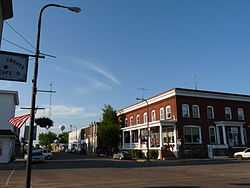
The old downtown, looking north up Central Avenue | |
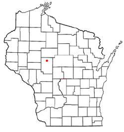 Location of Owen, Wisconsin | |
| Coordinates: 44°56′54″N 90°33′53″W / 44.94833°N 90.56472°WCoordinates: 44°56′54″N 90°33′53″W / 44.94833°N 90.56472°W | |
| Country | United States |
| State | Wisconsin |
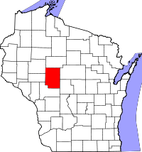
| County | Clark |
| Area[1] | |
| • Total | 1.84 sq mi (4.77 km2) |
| • Land | 1.77 sq mi (4.58 km2) |
| • Water | 0.07 sq mi (0.18 km2) |
| Elevation[2] | 1,243 ft (379 m) |
| Population (2010)[3] | |
| • Total | 940 |
| • Estimate (2012[4]) | 930 |
| • Density | 531.1/sq mi (205.1/km2) |
| Time zone | Central (CST) (UTC-6) |
| • Summer (DST) | CDT (UTC-5) |
| Area code(s) | 715 & 534 |
| FIPS code | 55-60825[5] |
| GNIS feature ID | 1577195[2] |
| Website |
cityofowen |
Owen is a city in Clark County in the U.S. state of Wisconsin. The population was 940 at the 2010 census. Owen is located directly east of the village of Withee, which is about half the size of Owen.
History
Owen was founded by an Eau Claire lumberman named John S. Owen, in the late 19th century.[6]
Geography
Owen is located at 44°56′54″N 90°33′53″W / 44.94833°N 90.56472°W (44.948330, -90.564740).[7]
According to the United States Census Bureau, the city has a total area of 1.84 square miles (4.77 km2), of which, 1.77 square miles (4.58 km2) is land and 0.07 square miles (0.18 km2) is water.[1]
Demographics
2010 census
As of the census[3] of 2010, there were 940 people, 419 households, and 252 families residing in the city. The population density was 531.1 inhabitants per square mile (205.1/km2). There were 485 housing units at an average density of 274.0 per square mile (105.8/km2). The racial makeup of the city was 96.7% White, 0.5% African American, 0.1% Native American, 0.1% Asian, 2.0% from other races, and 0.5% from two or more races. Hispanic or Latino of any race were 3.8% of the population.
There were 419 households of which 27.7% had children under the age of 18 living with them, 44.4% were married couples living together, 8.4% had a female householder with no husband present, 7.4% had a male householder with no wife present, and 39.9% were non-families. 35.8% of all households were made up of individuals and 16.2% had someone living alone who was 65 years of age or older. The average household size was 2.23 and the average family size was 2.87.
The median age in the city was 40.4 years. 23.7% of residents were under the age of 18; 8.8% were between the ages of 18 and 24; 22.1% were from 25 to 44; 25.5% were from 45 to 64; and 19.9% were 65 years of age or older. The gender makeup of the city was 48.2% male and 51.8% female.
2000 census
As of the census[5] of 2000, there were 936 people, 412 households, and 255 families residing in the city. The population density was 510.9 people per square mile (197.5/km²). There were 455 housing units at an average density of 248.4 per square mile (96.0/km²). The racial makeup of the city was 98.61% White, 0.64% African American, 0.43% Native American, 0.11% Asian, and 0.21% from two or more races. Hispanic or Latino of any race were 0.43% of the population.
There were 412 households out of which 26.5% had children under the age of 18 living with them, 48.3% were married couples living together, 10.2% had a female householder with no husband present, and 37.9% were non-families. 32.3% of all households were made up of individuals and 21.6% had someone living alone who was 65 years of age or older. The average household size was 2.27 and the average family size was 2.84.
In the city the population was spread out with 23.3% under the age of 18, 9.1% from 18 to 24, 23.9% from 25 to 44, 20.6% from 45 to 64, and 23.1% who were 65 years of age or older. The median age was 41 years. For every 100 females there were 90.2 males. For every 100 females age 18 and over, there were 86.5 males.
The median income for a household in the city was $27,368, and the median income for a family was $37,955. Males had a median income of $27,431 versus $20,547 for females. The per capita income for the city was $14,981. About 9.4% of families and 13.4% of the population were below the poverty line, including 19.4% of those under age 18 and 13.8% of those age 65 or over.
References
- ↑ 1.0 1.1 "US Gazetteer files 2010". United States Census Bureau. Retrieved 2012-11-18.
- ↑ 2.0 2.1 "US Board on Geographic Names". United States Geological Survey. 2007-10-25. Retrieved 2008-01-31.
- ↑ 3.0 3.1 "American FactFinder". United States Census Bureau. Retrieved 2012-11-18.
- ↑ "Population Estimates". United States Census Bureau. Retrieved 2013-06-24.
- ↑ 5.0 5.1 "American FactFinder". United States Census Bureau. Retrieved 2008-01-31.
- ↑ "John S. Owen House". City of Eau Claire Landmark Commission. Retrieved 2012-01-02.
- ↑ "US Gazetteer files: 2010, 2000, and 1990". United States Census Bureau. 2011-02-12. Retrieved 2011-04-23.
External links
| Wikimedia Commons has media related to Owen, Wisconsin. |
| |||||||||||||||||||||||||||||||||||||