Owariasahi, Aichi
| Owariasahi 尾張旭市 | ||
|---|---|---|
| City | ||
| ||
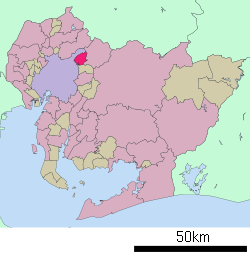 Location of Owariasahi in Aichi Prefecture | ||
 Owariasahi
| ||
| Coordinates: 35°12′48″N 137°02′19″E / 35.21333°N 137.03861°ECoordinates: 35°12′48″N 137°02′19″E / 35.21333°N 137.03861°E | ||
| Country | Japan | |
| Region | Chūbu (Tōkai) | |
| Prefecture | Aichi Prefecture | |
| Government | ||
| • - Mayor | Kōji Taniguchi | |
| Area | ||
| • Total | 21.03 km2 (8.12 sq mi) | |
| Population (February 2012) | ||
| • Total | 81,503 | |
| • Density | 3,880/km2 (10,000/sq mi) | |
| Time zone | Japan Standard Time (UTC+9) | |
| - Tree | Camphor Laurel | |
| - Flower | Sunflower | |
| Phone number | 0561-53-2111 | |
| Address | 2600-1 Hadara, Higashi-Ōmichi-chō, Owariasahi-shi, Aichi-ken 488-8666 | |
| Website |
www | |


City hall
Owariasahi (尾張旭市 Owariasahi-shi) is a city located in Aichi Prefecture, Japan.
As of February 2012, the city has an estimated population of 81,503 and a population density of 3880 persons per km². The total area is 21.03 km².
Geography
Owariasahi is located in west-central Aichi Prefecture, north of the Nagoya metropolis. The Aichi Prefectural Forest Park covers approximately 15% of its area.
Surrounding municipalities
History
During the Meiji period, the area was organized into villages under Higashikasugai District, Aichi. Asahi was proclaimed a town on August 5, 1948. Asahi was raised to city status on December 1, 1970. In order to prevent confusion with the city of Asahi, Chiba, the new city was named Owariasahi.
Transportation
Railways
Highways
Education
Notable people from Owariasahi
- Hiromitsu Kanehara, mixed martial artist
External links
| Wikimedia Commons has media related to Owariasahi, Aichi. |
- Owariasahi City official website (Japanese)
- Owariasahi City official website (English)
| ||||||||||||||||||||||||||||||||||||||||