Ovillers-la-Boisselle
| Ovillers-la-Boisselle | |
|---|---|
 Ovillers-la-Boisselle | |
|
Location within Picardy region  Ovillers-la-Boisselle | |
| Coordinates: 50°01′56″N 2°41′55″E / 50.0322°N 2.6986°ECoordinates: 50°01′56″N 2°41′55″E / 50.0322°N 2.6986°E | |
| Country | France |
| Region | Picardy |
| Department | Somme |
| Arrondissement | Péronne |
| Canton | Albert |
| Intercommunality | Pays du Coquelicot |
| Government | |
| • Mayor (2008) | Line Wattraint |
| Area1 | 9.61 km2 (3.71 sq mi) |
| Population (2006)2 | 362 |
| • Density | 38/km2 (98/sq mi) |
| INSEE/Postal code | 80615 / 80300 |
| Elevation |
80–153 m (262–502 ft) (avg. 115 m or 377 ft) |
|
1 French Land Register data, which excludes lakes, ponds, glaciers > 1 km² (0.386 sq mi or 247 acres) and river estuaries. 2 Population without double counting: residents of multiple communes (e.g., students and military personnel) only counted once. | |
Ovillers-la-Boisselle is a commune in the Somme department in Picardie in northern France.
Geography
The commune is situated on the D929 road, some 22 miles (35 km) northeast of Amiens.
Population
| 1962 | 1968 | 1975 | 1982 | 1990 | 1999 | 2006 |
|---|---|---|---|---|---|---|
| 312 | 333 | 336 | 390 | 392 | 371 | 362 |
| Starting in 1962: Population without duplicates | ||||||
History
The commune consists of the two villages of Ovillers and La Boisselle, which were destroyed during World War I. It was the site of heavy fighting during the 1916 Battle of the Somme, and particularly during the first day on the Somme.
Places of interest
- Ovillers British Military Cemetery.
- The Gordon Dump Cemetery.
- Lochnagar Crater, testimony to the ravages of the Battle of the Somme is 100 metres in diameter and 30 metres deep. It was created on 1 July 1916, the first day of the battle when a huge British mine was detonated.
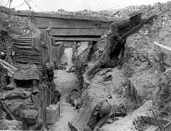
British trench (The Cheshires)

Lochnagar crater from World War I.
See also
- Communes of the Somme department
- Sausage Valley
References
External links
| Wikimedia Commons has media related to Ovillers-la-Boisselle. |
- Gordon Dump Cemetery (English)
- Ovillers-la-Boisselle on the Quid website (French)
- Lochnagar Crater (English)
- La Boisselle Study Group