Oster

Oster (Ukrainian: Осте́р, Russian: Остёр) is a city located where the Oster River flows into the Desna in Chernihiv Oblast of Ukraine. As of January 1, 2005, its population is 7,100.
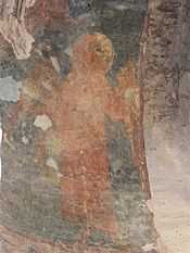
Today Oster is a river port with a cotton-textile factory and a food industry. Some parts of the old fortress in Oster and the remains of the tiny Saint Michael's Church (a.k.a. Yurii's Temple, the only preserved church of the medieval principality of Pereyaslav), which was constructed in 1098, have fortunately been preserved.
History
Oster was founded in 1098 by Vladimir Monomakh as Gorodets, a fortress belonging to Pereiaslav principality, which was later inherited by his son Prince Yuri Dolgoruki. In 1240, it was destroyed by the Mongol invasion, after which it remained in ruins for a century. After the destruction of the fort, a village arose in its place, named Stary Oster or Starogorodkaya. In the beginning of the 14th century a newer settlement arose closer to the Desna, named Oster.
Since 1356 Oster was under control of the Grand Duchy of Lithuania, later, under the Union of Lublin, and from 1569 Oster was part of the Polish-Lithuanian Commonwealth. In 1648 it became part of an uyezd of the Pereiaslav regiment. Since 1654, Oster was under control of the Russian Empire. In 1622, King Jan II Casimir granted Oster the Magdeburg rights and a coat of arms. After harsh battles of the Ukrainian War for Independence, the Polish rule was again established in Oster, but in February 1664, with support from the local population, the Poles were driven back by Cossacks and the Russians. In 1803, the city became an uyezd center of Chernigov Gubernia.
References
| |||||||||||||||||||||
| ||||||||||||||||||||||||||||
Coordinates: 50°56′55″N 30°52′52″E / 50.94861°N 30.88111°E