Osilnica
| Osilnica | |
|---|---|
| Settlement | |
|
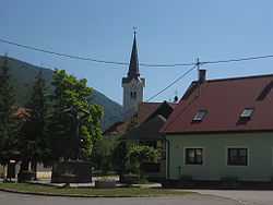
Center of Osilnica | |
_location_map.svg.png) Osilnica Location of Osilnica in Slovenia | |
| Coordinates: 45°33′N 14°44′E / 45.550°N 14.733°ECoordinates: 45°33′N 14°44′E / 45.550°N 14.733°E | |
| Country |
|
| Government | |
| • Mayor | Antun Volf |
| Area | |
| • Total | 1.1 km2 (0.4 sq mi) |
| Population (2012)[1] | |
| • Total | 90 |
| • Density | 82/km2 (210/sq mi) |
| Time zone | CET (UTC+01) |
| • Summer (DST) | CEST (UTC+02) |
Osilnica (German: Ossiunitz)[2] is a settlement in southern Slovenia. It is located on the left bank of the Kolpa River next to the border with Croatia. It is part of the traditional region of Lower Carniola and is now included in the Southeast Slovenia statistical region.[3] It is the largest settlement and the centre of the Municipality of Osilnica
History
The Osilnica volunteer fire department became a founding unit of the Kočevje municipal fire department on 28 August 1955.[4]
Church
The parish church in Osilnica is dedicated to Saints Peter and Paul and belongs to the Roman Catholic Diocese of Novo Mesto. It has a cruciform floor plan and was built in 1876 on the site of a 16th-century building.[5]
References
- ↑ "Osilnica". Place Names. Statistical Office of the Republic of Slovenia. Retrieved 7 August 2012.
- ↑ Leksikon občin kraljestev in dežel zastopanih v državnem zboru, vol. 6: Kranjsko. 1906. Vienna: C. Kr. Dvorna in Državna Tiskarna, p. 40.
- ↑ Kostel municipal site
- ↑ Gasilska zveza Kočevja: Zgodovina (Slovene)
- ↑ Slovenian Ministry of Culture register of national heritage reference number ešd 1808
External links
 Media related to Osilnica at Wikimedia Commons
- Osilnica on Geopedia
- Osilnica municipal site
| ||||||||||||