Osgoode, Ontario
- For the former township, see Osgoode Township, Ontario
| Osgoode | |
|---|---|
| Community | |
|
Osgoode main street | |
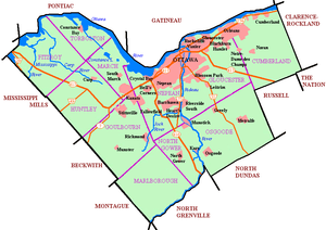
 Osgoode Location in Ottawa | |
| Coordinates: 45°08′40″N 75°36′15″W / 45.14444°N 75.60417°W | |
| Country | Canada |
| Province | Ontario |
| City | Ottawa |
| Established | 1827 |
| Incorporated | 1910 (Police Village of Osgoode Station) |
| Amalgamation |
1974 (Township of Osgoode) 2001 (City of Ottawa) |
| Government | |
| • Mayor | Jim Watson |
| • MPs | Pierre Poilievre |
| • MPPs | Lisa MacLeod |
| • Councillors | Doug Thompson |
| Area | |
| • Land | 2.65 km2 (1.02 sq mi) |
| Elevation | 90 m (300 ft) |
| Population (2011) | |
| • Total | 2,453 |
| • Density | 927.0/km2 (2,401/sq mi) |
| [1] | |
| Time zone | Eastern (EST) (UTC−5) |
| • Summer (DST) | EDT (UTC−4) |
Osgoode (also known as Osgoode Village) is a population centre in Osgoode Ward in the rural south end of Ottawa, Canada. It is located just 2kn east of the Rideau River. Until amalgamation in 2001, it was located in Osgoode Township. According to the Canada 2011 Census Osgoode had a population of 2,453.
History
It was originally part of Osgoode Township but it became part of Ottawa in 2001. Originally called Osgoode Station, its name was shortened to Osgoode in 1962.
Present day
Notable landmarks of the community include the Stuart Holmes Arena hockey, the Osgoode Community Centre and its surrounding recreation facilities, the local mall and numerous shops within the village.
References
External links
Coordinates: 45°08′40″N 75°36′15″W / 45.14444°N 75.60417°W