Orviston, Pennsylvania
| Orviston, Pennsylvania | |
|---|---|
| Census designated place | |
 Orviston Location in Pennsylvania | |
| Coordinates: 41°6′22″N 77°45′10″W / 41.10611°N 77.75278°WCoordinates: 41°6′22″N 77°45′10″W / 41.10611°N 77.75278°W | |
| Country | United States |
| State | Pennsylvania |
| County | Centre |
| Township | Curtin |
| Area | |
| • Total | 0.11 sq mi (0.28 km2) |
| • Land | 0.11 sq mi (0.28 km2) |
| • Water | 0.0 sq mi (0.0 km2) |
| Elevation | 849 ft (259 m) |
| Population (2010) | |
| • Total | 95 |
| • Density | 887/sq mi (342.4/km2) |
| Time zone | Eastern (EST) (UTC-5) |
| • Summer (DST) | EDT (UTC-4) |
| ZIP code | 16864 |
| FIPS code | 42-57160 |
| GNIS feature ID | 1183056 |
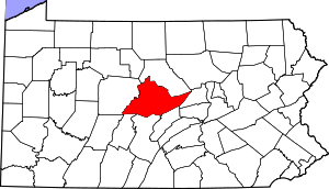
Orviston is an unincorporated community and census-designated place (CDP) in Curtin Township, Centre County, Pennsylvania, United States. As of the 2010 census, the population was 95.[1] It is located in far northern Centre County, near the Clinton County border. Beech Creek runs through the center of the town, flowing southeast towards Bald Eagle Creek in the West Branch Susquehanna River watershed.
References
- ↑ "Geographic Identifiers: 2010 Census Summary File 1 (G001): Orviston CDP, Pennsylvania". U.S. Census Bureau, American Factfinder. Retrieved April 17, 2015.
