Oruro, Bolivia
| Oruro Uru Uru | |||
|---|---|---|---|
 | |||
| |||
 Oruro Location within Bolivia | |||
| Coordinates: 17°58′S 67°07′W / 17.967°S 67.117°W | |||
| Country |
| ||
| Department | Oruro Department | ||
| Province | Cercado Province | ||
| Founded | November 1, 1606 | ||
| Government | |||
| • Mayor | Rossío Pimentel | ||
| Area | |||
| • Total | 1,633 km2 (631 sq mi) | ||
| Elevation | 3,735 m (12,254 ft) | ||
| Population (2012) | |||
| • Total | 264,700 | ||
| • Density | 160/km2 (420/sq mi) | ||
| Time zone | UTC-4 | ||
| Website | Official website | ||


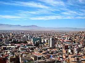
Oruro is a city in Bolivia with a population of 264,683 (2012 calculation),[1] located about equidistant between La Paz and Sucre at approximately 3709 meters above sea level. It is the capital of the department of Oruro. The city is also the seat of the Roman Catholic Diocese of Oruro. Oruro is subject to boom or bust cycles due to its dependence upon the mining industry, notably tin, tungsten (wolfram), silver and copper.
History
The city was first founded on November 1, 1606 by Don Manuel Castro de Padilla. as a silver mining center in the Urus region. At the time, it was named Real Villa de San Felipe de Austria after the Spanish monarch, Philip III. It was eventually abandoned as the silver mines became exhausted. Oruro was reestablished in the late nineteenth century, as a tin mining center,[2] Oruro being named after the native tribe "Uru-Uru". For a time, the La Salvadora tin mine was the most important source of tin in the world. Gradually, this resource became less plentiful, and Oruro again went into a decline, although its primary employer is still the mining industry.[2]
Economy
While traditionally based upon mining, and beginning in the late 20th Century additionally supported by tourism, the economy of Oruro grew in the early 21st Century by utilizing its economic connections to Chile, and transport by road through Chile to the Pacific port of Iquique, to open new connections to external markets, as well as utilizing the existing rail connection through Uyuni to the port at Antofagasta, Chile.[3] In addition, thanks to increased road building, it acted as a way station on the overland route of goods from the Atlantic port of Santos, Brazil, through Puerto Suárez and Santa Cruz to La Paz.[4]
Culture and education
Despite its economic decline, the city still manages to attract tourists to its carnival, the Carnaval de Oruro, considered one of the great folkloric events in South America for its masked "diablada".[5]
.JPG)
The Oruro Symphony Orchestra is based in Oruro. Aymara painter and printmaker Alejandro Mario Yllanes (1913–1960) was born here.[6]
The Universidad Técnica de Oruro, noted for its engineering school, is located in Oruro.[7]
Climate
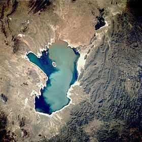
Oruro lies north of the salty lakes Uru Uru and Poopó and it is just three hours (by bus) from La Paz. Located at an altitude of 3709 meters above sea level, Oruro its well known for its cold weather. Warmer temperatures generally take place during August, September and October, after the worst of the winter chills and before the summer rains. From May to early July, night time temperatures combined with cool wind can bring the temperature down to about -20 °C. Summers are warmer, but despite the fact of being an arid area, there's quite a lot of rainfall between November and March. The Köppen Climate System describes the climate as Tropical and Subtropical Steppe, abbreviated BSk.[8] Due to the warm days and dry winters, snow is not a frequent occurrence as much as the bitter cold (especially at night); however flurries can fall usually once every few years (most recently on 13 June 2013- the first time in 3 years[9]).
| Climate data for Oruro | |||||||||||||
|---|---|---|---|---|---|---|---|---|---|---|---|---|---|
| Month | Jan | Feb | Mar | Apr | May | Jun | Jul | Aug | Sep | Oct | Nov | Dec | Year |
| Average high °C (°F) | 16 (61) |
15 (59) |
16 (61) |
16 (61) |
16 (61) |
15 (59) |
15 (59) |
16 (61) |
17 (63) |
19 (66) |
19 (66) |
17 (63) |
16.4 (61.7) |
| Average low °C (°F) | 3 (37) |
2 (36) |
2 (36) |
0 (32) |
−3 (27) |
−6 (21) |
−5 (23) |
−4 (25) |
−1 (30) |
0 (32) |
2 (36) |
3 (37) |
−0.6 (31) |
| Average precipitation mm (inches) | 94 (3.7) |
84 (3.3) |
51 (2.0) |
15 (0.6) |
5 (0.2) |
3 (0.1) |
3 (0.1) |
10 (0.4) |
15 (0.6) |
15 (0.6) |
33 (1.3) |
64 (2.5) |
392 (15.4) |
| Source: Weatherbase [10] | |||||||||||||
Main attractions
- Museo Patiño, former residence of "tin baron" Simón Iturri Patiño
- Museo Mineralógico (Mineralogical Museum): has exhibits of precious stones, minerals, and fossils
- Museo Etnográfico Minero (Ethnographical Mining Museum): housed in a mine tunnel, depicts methods of Bolivian mining
- Museo Nacional Antropológico Eduardo López Rivas(National Anthropological Museum): displays tools and information on the Chipayas and Urus tribes and Carnaval de Oruro.
- Churches: Catedral Nuestra Señora de la Asunción, Santuario de la Virgen del Socavón, Iglesia de Cunchupata
- Inti Raymi, a mine
Twin Cities
See also
References
- ↑ World Gazetteer
- ↑ 2.0 2.1 "Oruro: History". Lonely Planet.
- ↑ Ancalle, Milka Ruth Cayoja (2012). Oruro Como Centro Estratégico Comercial Internacional de Bolivia: Competitividad y Consecuencias del Proceso (PDF). (Master's Thesis, Pontifical Catholic University of Chile). Institute of Urban and Regional Studies, Pontifical Catholic University of Chile. Archived (PDF) from the original on 8 February 2014.
- ↑ Ancalle 2012, p. 27
- ↑ Kartomi, Margaret Joy and Blum, Stephen (1994). Music-Cultures In Contact: Convergences And Collisions. Basel, Switzerland: Gordon and Breach. p. 63. ISBN 978-2-88449-137-2.
- ↑ Raynor, Vivien. ART; Works by a Vanished Bolivian Painter. New York Times. 5 April 1992 (retrieved 2 May 2009)
- ↑ "Official Facultad Nacional de Ingeniería (National Engineering School) webpage" (in Spanish).
- ↑ Climate Summary for Oruro, Bolivia
- ↑ "Después de tres años nevó en la ciudad de Oruro". La Patria.
- ↑ "Weatherbase: Historical Weather for Oruro". Weatherbase. 2011. Retrieved on November 24, 2011.
- ↑ http://www.sister-cities.org/interactive-map/Salt%20Lake%20City,%20Utah
External links
| Wikimedia Commons has media related to Oruro. |
- Oruro's full information about hotels, history, carnival, tourism, pictures, videos, and news.
- Weather in Oruro
- Carnaval de Oruro
- Oruro's Carnival
- Oruro's Carnival
- Oruro
Coordinates: 17°58′S 67°07′W / 17.967°S 67.117°W
| |||||||||||||||||
