Ortaffa
| Ortaffa Hortafà | ||
|---|---|---|
|
The church of Sainte-Eugénie, in Ortaffa | ||
| ||
 Ortaffa | ||
|
Location within Languedoc-Roussillon region  Ortaffa | ||
| Coordinates: 42°34′51″N 2°55′33″E / 42.5808°N 2.9258°ECoordinates: 42°34′51″N 2°55′33″E / 42.5808°N 2.9258°E | ||
| Country | France | |
| Region | Languedoc-Roussillon | |
| Department | Pyrénées-Orientales | |
| Arrondissement | Perpignan | |
| Canton | Elne | |
| Intercommunality | secteur d'Illibéris | |
| Government | ||
| • Mayor (2001–2008) | Raymond Pla | |
| Area1 | 8.49 km2 (3.28 sq mi) | |
| Population (1999)2 | 1,093 | |
| • Density | 130/km2 (330/sq mi) | |
| INSEE/Postal code | 66129 / 66560 | |
| Elevation |
19–90 m (62–295 ft) (avg. 44 m or 144 ft) | |
|
1 French Land Register data, which excludes lakes, ponds, glaciers > 1 km² (0.386 sq mi or 247 acres) and river estuaries. 2 Population without double counting: residents of multiple communes (e.g., students and military personnel) only counted once. | ||


Ortaffa (Catalan: Hortafà) is a commune in the Pyrénées-Orientales department in southern France.
Geography
Ortaffa is located in the canton of Elne and in the arrondissement of Perpignan.
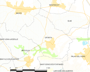
Map of Ortaffa and its surrounding communes
See also
References
| Wikimedia Commons has media related to Ortaffa. |