Orpheus Monument

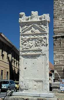
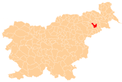
The Orpheus Monument (Slovene: Orfejev spomenik) is a Roman monument in Ptuj, Slovenia, an almost 5 metres (16 ft) high and about 1.8 metres (5 ft 11 in) wide stele, carved of white Pohorje marble. It is located at Slovene Square (Slovene: Slovenski trg), the town's central square, in front of the Town Tower. It is the oldest public monument preserved in its original location in Slovenia,[1] the largest discovered monument from the Roman province of the Pannonia Superior,[2] and the symbol of Ptuj.[3]
The monolith was originally a grave marker, erected in the 2nd century AD to honor the memory of Marcus Valerius Verus, the duumvir (mayor) of Roman Poetovio.[3] In the Middle Ages, it was used as a pillory.[3] Criminals were tied to the iron rings attached to its lower part.[2] Since March 2008, it has the status of a national cultural monument.[3]
The central relief illustrates scenes from the myth of Orpheus, who plays the lyre while mourning his lost love Eurydice. Other reliefs depict the Greek-Egyptian god Serapis, who symbolizes the hope of resurrection. The corners each contain a prone lion gnawing on a ram's head. Beneath this, a relief in the tympanum depicts the Moon goddess Selene, leaning over her dead lover Endymion. All the reliefs and inscriptions are badly eroded.[4]
References
- ↑ Slovenia info
- ↑ 2.0 2.1 "The Povoden Museum and the Orpheus Monument". Ptuj Ormož Regional Museum. Retrieved 30 May 2012.
- ↑ 3.0 3.1 3.2 3.3 "7754: Ptuj - Orfejev spomenik" [7754: Ptuj – Orpheus Monument]. Register nepremične kulturne dediščine [Registry of Immovable Cultural Heritage] (in Slovenian). Ministrstvo za kulturo Republike Slovenije. Retrieved 30 May 2012.
- ↑ Lamut, Brane, ed. (1993). Ptujski arheološki zbornik: ob 100-letnici muzeja in Muzejskega društva [Ptuj Collection of Archeological Papers: On the 100th Anniversary of the Museum and the Museum Society] (in Slovene, with abstracts in English). Regional Museum of Ptuj. COBISS 35226880.
External links
 Media related to Orpheus Monument at Wikimedia Commons
| ||||||||||||||||||||||
Coordinates: 46°25′12.33″N 15°52′13.37″E / 46.4200917°N 15.8703806°E
