Orlické Podhůří
| Orlické Podhůří | |||
|---|---|---|---|
| Municipality | |||
 | |||
| |||
 Orlické Podhůří | |||
| Coordinates: 50°0′N 16°21′E / 50.000°N 16.350°ECoordinates: 50°0′N 16°21′E / 50.000°N 16.350°E | |||
| Country |
| ||
| Region | Pardubice | ||
| District | Ústí nad Orlicí | ||
| Area | |||
| • Total | 13.52 km2 (5.22 sq mi) | ||
| Elevation | 426 m (1,398 ft) | ||
| Population (1.1.2013) | |||
| • Total | 641 | ||
| • Density | 47/km2 (120/sq mi) | ||
| Postal code | 561 11 to 562 01 | ||
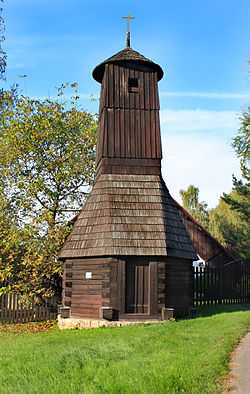
Orlické Podhůří is a village and municipality (obec) in the Ústí nad Orlicí District, Pardubice Region of the Czech Republic.
The municipality covers an area of 13.52 square kilometres (5.22 sq mi), and has a population of 606 (as at 3 July 2006).
Orlické Podhůří lies approximately 6 kilometres (4 mi) north-west of Ústí nad Orlicí, 40 km (25 mi) east of Pardubice, and 138 km (86 mi) east of Prague.
References
| Wikimedia Commons has media related to Orlické Podhůří. |