Oriximiná
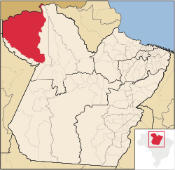
Oriximiná is the westernmost and second largest (by territorial area) city in the Brazilian state of Pará. It is also the fourth largest in the country. The city lies on the Trombetas river, 40 km northwest of Óbidos. The city is crossed by the Equator.
Oriximiná is served by Oriximiná Airport located 8km from downtown Oriximiná. Porto Trombetas Airport located in the district of Porto Trombetas 70km away serves the population residing and working for the Mineração Rio do Norte S/A.
References
|
|---|
| | | Mesoregion
Baixo Amazonas | | |
|---|
| Mesoregion
Marajó | Arari | |
|---|
| Furos de Breves | |
|---|
| Portel | |
|---|
|
|---|
| Mesoregion
Metropolitana de Belém | |
|---|
| Mesoregion
Nordeste Paraense | Bragantina | |
|---|
| Cametá | |
|---|
| Guamá | |
|---|
| Salgado | |
|---|
| Tomé-Açu | |
|---|
|
|---|
| Mesoregion
Sudeste Paraense | Conceição do Araguaia | |
|---|
| Marabá | |
|---|
| Paragominas | |
|---|
| Parauapebas | |
|---|
| Redenção | |
|---|
| São Félix do Xingu | |
|---|
| Tucurui | |
|---|
|
|---|
| Mesoregion
Sudoeste Paraense | |
|---|
|