Orfeas
| Orfeas Ορφέας | |
|---|---|
 Orfeas | |
|
Location within the regional unit 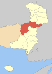 | |
| Coordinates: 41°16′N 26°01′E / 41.267°N 26.017°ECoordinates: 41°16′N 26°01′E / 41.267°N 26.017°E | |
| Country | Greece |
| Administrative region | East Macedonia and Thrace |
| Regional unit | Evros |
| Municipality | Soufli |
| Districts | 7 |
| • Municipal unit | 643.266 km2 (248.366 sq mi) |
| Elevation | 20 m (70 ft) |
| Population (2001)[1] | |
| • Municipal unit | 6,146 |
| • Municipal unit density | 9.6/km2 (25/sq mi) |
| Time zone | EET (UTC+2) |
| • Summer (DST) | EEST (UTC+3) |
| Postal code | 680 04 |
| Area code(s) | 25530 |
| Vehicle registration | OP |
Orfeas (Greek: Ορφέας), named after the mythical musician Orpheus, is a former municipality in the Evros regional unit, East Macedonia and Thrace, Greece. Since the 2011 local government reform it is part of the municipality Soufli, of which it is a municipal unit.[2] Its land area is 643.266 km² (248.366 sq mi) and its 2001 census population 6,146 inhabitants. It is located in the north-central part of Evros, and borders both southeastern Bulgaria and northwestern Turkey. The seat of the municipality was in Lavara (pop. 1,580 in 2001). Much of the land is mountainous and forested to the west, extending up to the Rhodope regional unit. It is linked with GR-51 (Alexandroupoli - Orestiada - Edirne in Turkey and Svilengrad in Bulgaria). The town of Lávara sits on a plain. It is located SE of Svilengrad, S of Edirne, Turkey and Orestiada, and 13 km N of Soufli and 78 km N of Alexandroupoli. The municipality's next largest towns are Protokklísi (pop. 669), Amório (552), Méga Déreio (545), and Agriáni (451).
History
The town were rare affected by the Evros river flooding of February 17 to 22, 2005. Flood warnings were reported that time. It devastated much of the town on Wednesday March 2, 2005 and continued for several days. On Friday March 4, flood waters plummeted slowly. It amounted up to 5 m or 5,000 mm of rainfall causing the rover to overflow its banks. It flooded buildings, properties and stores. It also left people stranded in their homes and buildings. 50 houses were damaged. It was the worst flooding in nearly 50 years. The rail south of Lavara and near the station were also flooded and was closed that time.
Geography
Forests dominate the river banks and parts of the plain. Much of the area are used for farming. The main production are cattle, fruits and vegetables and some flowers. The mountains dominate further west.
Subdivisions
The municipal unit Orfeas is subdivided into the following communities (constituent villages in brackets):
- Lavara
- Amorio
- Kyriaki
- Mandra
- Mavrokklisi (Mavrokklisi, Korymvos)
- Mikro Dereio (Mikro Dereio, Geriko, Goniko, Mega Dereio, Petrolofos, Roussa, Sidirochori)
- Protokklisi (Protokklisi, Agriani)
Historical population
| Year | Population Lavara | Population municipality |
|---|---|---|
| 1981 | 2,117 | - |
| 1991 | 2,173 | 6,905 |
| 2001 | 1,580 | 6,146 |
References
- ↑ De Facto Population of Greece Population and Housing Census of March 18th, 2001 (PDF 39 MB). National Statistical Service of Greece. 2003.
- ↑ Kallikratis law Greece Ministry of Interior (Greek)
External links
- http://thesaurus.duth.gr/english/moredata.asp?Perioxh_ID=42&Subj=255
- Evros floods
- Critical hours in Lavara during the floods - pathfinder.gr
- http://orfeas.evros.gr/lavara.htm (in Greek)
 |
Ivaylovgrad (Bulgaria) | Metaxades | Didymoteicho | |
| Kechros | |
Meriç (Turkey) | ||
| ||||
| | ||||
| Sapes, Arriana, Alexandroupoli | Soufli |
| ||||||||||||||