Oregon Route 42
| ||||
|---|---|---|---|---|
 | ||||
| Route information | ||||
| Maintained by ODOT | ||||
| Length: | 73.31 mi (117.98 km) | |||
| Existed: | 1932 – present | |||
| Major junctions | ||||
| West end: |
| |||
|
| ||||
| East end: |
| |||
| Highway system | ||||
| ||||

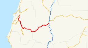
Oregon Route 42 (OR 42) is an Oregon state highway which runs between U.S. Route 101 on the Oregon Coast, near Coos Bay, and Green, a few miles south of Roseburg on Interstate 5. It is known as the Coos Bay-Roseburg Highway No. 35 (see Oregon highways and routes). At Coquille, there is a split in the route, as Oregon Route 42S heads southwest toward Bandon.
The section of Oregon Route 42 between its junction with U.S. Route 101 south of Coos Bay and its junction with Oregon Route 42S in Coquille was once a part of U.S. Route 101. When U.S. Route 101 was moved to an alignment closer to the ocean, Oregon Route 42 was extended along the northernmost section and Oregon Route 42S was created along the southernmost section.
Route description
OR 42 is known internally by the Oregon Department of Transportation (ODOT) as the Coos Bay-Roseburg Highway No. 35.[1] The entire highway is designated as part of the National Highway System,[2] which includes roadways important to the national economy, defense, and mobility.[3] The entire highway has also been designated as a freight route by ODOT.[4]
Major intersections
Mileposts do not reflect actual mileage due to realignments.
| County | Location | mi[5] | km | Destinations | Notes |
|---|---|---|---|---|---|
| Coos | 0.00 | 0.00 | Interchange | ||
| Coquille | 10.85 | 17.46 | |||
| 23.48 | 37.79 | Powers (OR 542) | Interchange | ||
| Douglas | Winston | 73.37 | 118.08 | West end of OR 99 overlap | |
| 76.22 | 122.66 | East end of OR 99 overlap | |||
| 77.20 | 124.24 | Interchange | |||
1.000 mi = 1.609 km; 1.000 km = 0.621 mi
| |||||
Spur route
| |
|---|---|
| Location: | Bandon–Coquille |
| Length: | 16.94 mi (27.26 km) |
Oregon Route 42S is an Oregon state highway which is located entirely within Coos County. It runs between U.S. Route 101 at Bandon and Coquille on Oregon Route 42. It is known as the Coquille-Bandon Highway No. 244 (see Oregon highways and routes). It serves as an important link between Interstate 5 and the southern Oregon Coast, as it forms the southernmost all-season connection between the two in Oregon. Oregon Route 42S used to be a part of U.S. Route 101, and was created when US 101 was realigned closer to the ocean.
References
- ↑ "Routes / State Highway Cross Reference Table". Oregon Department of Transportation. Retrieved April 18, 2014.
- ↑ National Highway System: Oregon (PDF) (Map). Federal Highway Administration. October 1, 2012. Retrieved April 18, 2014.
- ↑ "What is the National Highway System?". Federal Highway Administration. September 26, 2012. Retrieved April 18, 2014.
- ↑ State Highway Freight System (PDF) (Map). Oregon Department of Transportation. April 2013. Retrieved April 18, 2014.
- ↑ Oregon Department of Transportation, Public Road Inventory (primarily the Digital Video Log), accessed April 2008
External links
 Media related to Oregon Route 42 at Wikimedia Commons
- OR 42 at ORoads
- OR 42S at ORoads