Oregon Route 34
| ||||
|---|---|---|---|---|
 | ||||
| Route information | ||||
| Maintained by ODOT | ||||
| Length: | 83.98 mi (135.15 km) | |||
| Major junctions | ||||
| West end: |
| |||
|
| ||||
| East end: |
| |||
| Highway system | ||||
| ||||

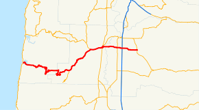
Oregon Route 34 is a state highway in the U.S. state of Oregon that runs between the city of Waldport on the Oregon Coast and the city of Lebanon in the western part of the state. West of Philomath, the highway is known as the Alsea Highway No. 27 (see Oregon highways and routes). Between Philomath and Corvallis, it is part of the Corvallis-Newport Highway No. 33. In Corvallis, OR 34 includes a brief concurrency with U.S. Route 20 and OR 99W over the Pacific Highway West No. 1W. Between Corvallis and Lebanon, it is known as the Corvallis-Lebanon Highway No. 210.
Route description
Oregon Route 34 begins (at its western terminus) at its junction with U.S. Route 101 in Waldport. It follows the Alsea River through Tidewater to the community of Alsea, where it heads northeast to its junction with U.S. Route 20 near Philomath. OR 34 and US 20 share the same roadway between Philomath and the college town of Corvallis. At a grade-separated interchange in eastern Corvallis, OR 34 leaves U.S. 20 (which heads north with Oregon Route 99W) and crosses the Willamette River into Linn County. From Corvallis to its junction with Interstate 5 east of Tangent, OR 34 is a four-lane undivided highway, with an interchange at its junction with Oregon Route 99E in Tangent. OR 34 continues east to its eastern terminus at U.S. 20 in Lebanon.
Major intersections
- Note: OR 34 uses several different highways (see Oregon highways and routes); the milepoint column shows mileage along these highways, not adjusted for equations, with the highway number in front.
| County | Location | mi[1] | km | Destinations | Notes |
|---|---|---|---|---|---|
| Lincoln | Waldport | 0.00 | 0.00 | ||
| Benton | Alsea | 39.81 | 64.07 | Lobster Valley, Alsea Falls (OR 501) | |
| Flynn | 58.55 49.76 | 94.23 80.08 | West end of US 20 overlap | ||
| Corvallis | 55.86 | 89.90 | Interchange | ||
| 55.94 | 90.03 | East end of US 20 overlap; interchange; eastbound exit and westbound entrance | |||
| Linn | 56.80 0.34 | 91.41 0.55 | |||
| Tangent | 7.65 | 12.31 | Interchange | ||
| 10.04 | 16.16 | ||||
| Lebanon | 18.13 | 29.18 | |||
1.000 mi = 1.609 km; 1.000 km = 0.621 mi
| |||||
See also
References
- ↑ Oregon Department of Transportation, Public Road Inventory (primarily the Digital Video Log), accessed March 2008