Oregon Route 213
| ||||
|---|---|---|---|---|
 | ||||
| Route information | ||||
| Maintained by ODOT | ||||
| Length: | 55.66 mi (89.58 km) | |||
| Major junctions | ||||
| South end: |
| |||
|
| ||||
| North end: |
| |||
| Highway system | ||||
| ||||

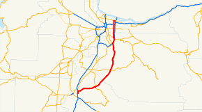
Oregon Route 213 is an Oregon state highway that serves the eastern Willamette Valley between Portland and Salem. It is a north–south route. The route (except for its southernmost segment) is known as the Cascade Highway, though specific segments are generally better known by more localized names.
Route description

OR 213 begins on the grounds of Portland International Airport at an intersection with Airport Way, halfway between I-205 and the airport terminal. It heads south, where it is known as N.E. and S.E. 82nd Avenue,[1] a major five-lane thoroughfare through east Portland, until reaching its other end at OR 224 in the Clackamas area. Throughout this stretch, OR 213 runs parallel to Interstate 205 and thus mainly serves local traffic. However, traffic can still be heavy due to incidents on I-205 as well as the street's many businesses. Also, the street has some of the highest bus ridership in the region, along Tri-Met Route 72, which connects with the MAX Blue Line at the 82nd Avenue MAX Station.
OR 213 then follows I-205 for approximately 3 miles (4.8 km), before departing the freeway in Oregon City. It then proceeds south on a four-lane expressway through a scenic canyon on Oregon City's eastern edge until it intersects with Molalla Avenue in the vicinity of Clackamas Community College. This route goes by a number of names, known alternately as 82nd Drive, the Oregon City Bypass or the Trails End Highway. It then continues south as a two-lane, undivided route, through the communities of Carus, Mulino, and Liberal. In Liberal, Oregon Route 213 becomes the "Cascade Highway" (formerly Route 215) and continues south. Approximately 12 miles (19 km) south of Molalla, the highway enters the town of Silverton, where it intersects Oregon Route 214. Oregon Route 213 then veers southwest along Silverton Road until it reaches Salem; in Salem it follows an alignment consisting of Silverton Road, Lancaster Drive, and Market Street until its southern terminus at Interstate 5. A separate roadway (never maintained by the Oregon Department of Transportation) known as the Cascade Highway South[2] continues south from Silverton (previously Oregon Route 215 but now devoid of any route number) until an intersection with OR 22 just north of Stayton.
Highways comprising
OR 213 comprises the following named highways (see Oregon highways and routes) from north to south:
- The Cascade Highway North No. 68;
- Part of the Clackamas Highway No. 171 (concurrent with OR 224);
- Part of the East Portland Freeway No. 64 (concurrent with I-205);
- The Cascade Highway South No. 160;
- Part of the Hillsboro-Silverton Highway No. 140 (concurrent with OR 214);
- Main Street in Silverton;
- McClaine Street in Silverton;
- Silverton Road in Marion County;
- Lancaster Drive in Salem; and
- Market Street in Salem.
History
For the most part, the alignment of OR 213 has remained the same over the years; however the following re-alignments have occurred:
- OR 213 used to have a full connection with I-84 prior to the construction of I-205. Now, one can only enter I-84 headed westbound (towards downtown Portland) or exit I-84 onto OR 213 headed eastbound (coming from Portland). The OR 213 and I-84 intersection is also where OR 213 crosses over the MAX Blue, Red, and Green light rail lines at the Northeast 82nd Avenue station.
- Prior to the construction of the OR 224 Expressway, OR 213 headed south from Sunnyside Road, turned east onto what is currently Sunnybrook, turned again south onto 84th Avenue, proceeded onto what is now Ambler, and continued onto 82nd Drive through Clackamas.
- Prior to the construction of I-205, OR 213 shared an alignment with OR 212 between Clackamas and Oregon City along a local street known as 82nd Drive.
- Prior to the construction of the Oregon City Bypass in the late 1980s, the highway was routed on an alignment through Oregon City along Washington and 7th Streets and Molalla Avenue.
- In Salem, the highway did not used to connect to I-5 via Lancaster Drive and Market Streets; instead it continued west along Silverton Road (passing under I-5 but with no interchange) until the latter street's intersection with the old OR 99E alignment (Portland Road/Fairgrounds Road)
Major intersections
- Note: OR 213 uses several different highways (see Oregon highways and routes); the milepoint column shows mileage along these highways, not adjusted for equations, with the highway number in front.
| County | Location | Milepoint[3] | Destinations | Notes |
|---|---|---|---|---|
| Marion | Salem | Interchange | ||
| Silverton | West Main Street – Stayton | |||
| 140 50.54 | South end of OR 214 overlap | |||
| 140 50.50 160 29.65 |
North end of OR 214 overlap | |||
| Clackamas | Blackman's Corner | 160 16.10 | ||
| Oregon City | 160 0.00 64 10.20 |
Interchange; south end of I-205 overlap | ||
| Gladstone | 64 11.05 | Gladstone | Interchange | |
| 64 12.67 | Interchange; south end of OR 224 overlap | |||
| 64 13.11 171 4.73 |
Interchange; north end of I-205 overlap; northbound exit and southbound entrance | |||
| 171 4.17 68 10.02 |
Interchange; north end of OR 224 overlap | |||
| Multnomah | Portland | 68 4.75 | ||
| 68 2.27 | Interchange | |||
| 68 0.95 | Sandy Boulevard – Hollywood District | Former US 30 Bus. | ||
| 68 0.23 | Interchange | |||
| 68 0.10 | Columbia Boulevard | Interchange | ||
| 68 0.00 | Portland Airport | Continuation beyond Columbia Boulevard |
References
- ↑ "82nd Avenue at Jonesmore Improvements". Oregon Department of Transportation. Retrieved 2012-04-14.
- ↑ "OR 213 (Cascade Highway South): I-205 to Conway Drive". Oregon Department of Transportation. Retrieved 2012-04-14.
- ↑ Oregon Department of Transportation, Public Road Inventory (primarily the Digital Video Log), accessed April 2008