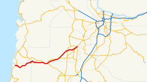
Oregon Route 18
| ||||
|---|---|---|---|---|
 | ||||
| Route information | ||||
| Maintained by ODOT | ||||
| Length: | 53.05 mi[1] (85.38 km) | |||
| Existed: | 1932 – present | |||
| Major junctions | ||||
| West end: |
| |||
|
| ||||
| East end: |
| |||
| Highway system | ||||
| ||||

Oregon Route 18 is a state highway that runs between the Oregon Coast, near Lincoln City and the Willamette Valley, near Dayton. It is also known as the Salmon River Highway No. 39 (see Oregon highways and routes), named after the river its westernmost segments run parallel to.
Route description
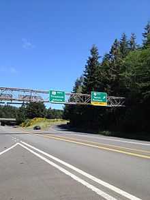
OR 18 begins (at its western terminus) at a junction with U.S. Route 101, a few miles north of Lincoln City near Otis Junction. From there it winds eastward though the coast range along the Salmon River, past Rose Lodge and through a stand of timber known as the Van Duzer Corridor. Emerging from the coast range, it enters the fringes of the Willamette Valley in the community of Grand Ronde. It is briefly joined by Oregon Route 22 at a location known as Valley Junction, and overlaps OR 22 in a four-mile (6 km) stretch between Grand Ronde and Willamina, at which point OR 22 heads southeast towards Salem and OR 18 continues northeast towards the Portland area. Also in Willamina, a business route veers off to the north to serve the cities of Willamina and Sheridan; east of Sheridan the business route rejoins the mainline. This business loop was the former route and highway until 1957, when the current Oregon Route 18 was built as a bypass.
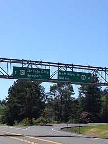
The highway continues northeast on a straight and level course through Willamette Valley farmland, including the community of Bellevue which intersects with Oregon Route 153, until it intersects with Oregon Route 99W just south of McMinnville. In the McMinnville area, OR 99W serves as the primary business route (entering the downtown core) whereas OR 18 is a bypass route. Two interchanges along OR 18 provide access to McMinnville, including Three-Mile Lane, a spur of the highway. Oregon Route 18 provides direct access to the McMinnville Airport and the Evergreen Aviation Museum, home of the Spruce Goose. East of McMinnville, Oregon Route 18 intersects Oregon Route 233, with which it overlaps until its eastern terminus, and Oregon Route 221; the latter near the city of Dayton. It then crosses over the Yamhill River and terminates at a second junction with OR 99W. Typically, commuters continue north on OR 99W into the Portland area.
The highway is rather variant in its configuration. For most of its length, the highway is a two-lane undivided highway, with intersections and cross traffic. There are some limited-access stretches in the "bypass" sections (around the Willamina/Sheridan area, and near McMinnville and Dayton), and the occasional interchange in these stretches. In addition, there is a stretch between Willamina and Sheridan where the highway becomes a 4-lane divided expressway.
Currently, the route has a rather notorious reputation among motorists in Oregon, with a relatively high number of fatal accidents. The opening of two casinos, one in Grand Ronde and one in Lincoln City, have greatly increased traffic on OR 18. (In addition, the stretch of Oregon Route 99W immediately north of Dayton, through Dundee and Newberg, is a notorious traffic bottleneck.) Portions of Oregon Route 18 have been designated a safety corridor.
There are two proposed expansions to the highway. One is a project which would widen Oregon Route 18 to a four-lane expressway in the stretch between Grand Ronde and Willamina; an area where increased volume (largely due to the casino) has caused significant delays. This project is now completed with an overpass that closed down and blocked off a very fatal intersection.
The second project is a new bypass around the Newberg-Dundee area intended to alleviate severe congestion that occurs along 99W. This new route will either be an expressway or a freeway. A route number for this latter project has not been published; however, planning documents and maps present it as an extension to Oregon Route 18. Construction on the first 4-mile (6.4 km) section began in June 2013, with the section scheduled for completion in summer 2016.[2] This section will connect Oregon 219 south of Newberg to 99W west of Dundee.[2] The entire 11-mile (18 km) bypass is expected to cost $262 million and will have four lanes from the current eastern terminus of Route 18 south of Dundee and Newberg and reconnect to 99W east of Newberg.[2]
Oregon Route 18 Business
| |
|---|---|
| Location: | Sheridan |
| Length: | 8.60 mi (13.84 km) |
| Existed: | 1957–present |
Oregon Route 18 Business is a business route state highway in the U.S. state of Oregon that runs parallel to Oregon Route 18 between the Willamina, and Sheridan, in the Yamhill Valley. It is also known as the Willamina-Sheridan Highway No. 157 (see Oregon highways and routes), and as the West Valley Highway.[3]
Oregon 18B begins (at its western terminus) at a junction with Oregon Route 18 and Oregon Route 22, at Valley Junction near Willimina. From there it travels eastward just north of the South Yamhill River. The river occasionally floods and closes the road.[4] It passes through the community of Shipley, before entering Sheridan. OR 18B then reconnects to OR 18 at the eastern edge of Sheridan.
The business loop was the former main route and highway until 1957, when the current Oregon Route 18 was built as a bypass. Route 18 Business is 8.60 miles (13.84 km) long.[5] The only traffic light on the road is in Sheridan at the intersection of 18B and Bridge Street where Sheridan Bridge crosses the South Yamhill River. In Sheridan the highway is Main Street. It is classified as a Rural Major Connector highway.[5]
Business 18 averages approximately 5,900 vehicles per day at its eastern terminus and 6,000 near the western terminus in Willimina.[6] Traffic averages around 5,400 vehicles per day between those two points.[6]
Major intersections
- Note: mileposts do not reflect actual mileage due to realignments.
| County | Location | mi[1] | km | Exit | Destinations | Notes |
|---|---|---|---|---|---|---|
| Lincoln | -0.22 | −0.35 | — | Interchange | ||
| Otis Junction | 1.31 | 2.11 | Old Scenic Highway 101 | |||
| Polk | 22.60 | 36.37 | — | Spirit Mountain Casino | Interchange | |
| Valley Junction | 23.04 | 37.08 | West end of OR 22 overlap | |||
| 27.16 | 43.71 | — | Interchange | |||
| 27.28 | 43.90 | — | East end of OR 22 overlap; interchange | |||
| Yamhill | Sheridan | 32.60 | 52.46 | 33 | Sheridan | Interchange |
| 33.82 | 54.43 | 34 | Interchange; westbound exit and eastbound entrance | |||
| Bellevue | 36.93 | 59.43 | Amity, Salem (OR 153) | |||
| McMinnville | 44.36 | 71.39 | — | Interchange | ||
| 46.13 | 74.24 | — | McMinnville (McMinnville Spur) | Interchange | ||
| 49.91 | 80.32 | West end of OR 233 overlap | ||||
| Dayton | 51.37 | 82.67 | — | Interchange | ||
| 52.71 | 84.83 | East end of OR 223 overlap | ||||
1.000 mi = 1.609 km; 1.000 km = 0.621 mi
| ||||||
References
- ↑ 1.0 1.1 Oregon Department of Transportation, Public Road Inventory (primarily the Digital Video Log), accessed April 2008
- ↑ 2.0 2.1 2.2 Richard, Terry (July 30, 2013). "Newberg-Dundee Bypass finally under construction as non-toll state highway". The Oregonian. Retrieved 30 July 2013.
- ↑ 38--Taylor Lumber and Treating (TLT) Superfund Site-Specific Remedial Action. Environmental Protection Agency. Retrieved on March 18, 2008.
- ↑ KATU Storm blog for Monday, Dec. 3, 2007. KATU. Retrieved on March 18, 2008.
- ↑ 5.0 5.1 Functional Classification and National Highway System Status on Oregon State Highways. Oregon Department of Transportation. Retrieved on March 18, 2008.
- ↑ 6.0 6.1 Traffic Flow Map 2004. Oregon Department of Transportation. Retrieved on March 18, 2008.