Oradour-sur-Glane (commune)
| Oradour-sur-Glane | ||
|---|---|---|
|
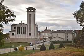
The new village of Oradour-sur-Glane | ||
| ||
 Oradour-sur-Glane | ||
|
Location within Limousin region  Oradour-sur-Glane | ||
| Coordinates: 45°55′58″N 1°01′57″E / 45.9328°N 1.03250°ECoordinates: 45°55′58″N 1°01′57″E / 45.9328°N 1.03250°E | ||
| Country | France | |
| Region | Limousin | |
| Department | Haute-Vienne | |
| Arrondissement | Rochechouart | |
| Canton | Saint-Junien-Est | |
| Intercommunality | Vienne Glane | |
| Government | ||
| • Mayor (2008–2014) | Raymond Frugier | |
| Area1 | 38.16 km2 (14.73 sq mi) | |
| Population (2007)2 | 2,205 | |
| • Density | 58/km2 (150/sq mi) | |
| INSEE/Postal code | 87110 / 87520 | |
| Elevation |
227–312 m (745–1,024 ft) (avg. 285 m or 935 ft) | |
|
1 French Land Register data, which excludes lakes, ponds, glaciers > 1 km² (0.386 sq mi or 247 acres) and river estuaries. 2 Population without double counting: residents of multiple communes (e.g., students and military personnel) only counted once. | ||

Oradour-sur-Glane (Occitan: Orador de Glana) is a commune in the Haute-Vienne department in the Limousin region in west-central France, and the name of main village within the commune. The original village was destroyed on 10 June 1944, when 642 of its inhabitants, including women and children, were massacred by a Nazi German Waffen-SS company. A new village was built after the war on a nearby site, but on the orders of the then French president, Charles de Gaulle, the original has been maintained as a permanent memorial. The Centre de la mémoire d'Oradour museum is beside the historic site.
Gallery
-
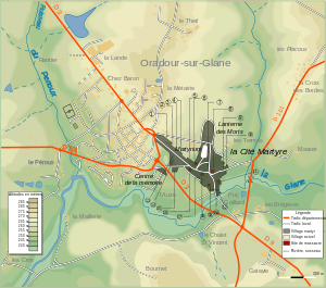
Map showing modern and former village
-
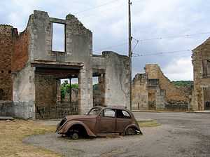
Ruined village
Population
| 1806 | 1820 | 1876 | 1901 | 1911 | 1921 | 1936 | 1946 | 1954 | 1962 | 1968 | 1975 | 1982 | 1990 | 1999 | 2006 | 2008 |
|---|---|---|---|---|---|---|---|---|---|---|---|---|---|---|---|---|
| 1,222 | 1,585 | 1,903 | 1,966 | 2,019 | 1,789 | 1,574 | 1,145 | 1,450 | 1,540 | 1,671 | 1,759 | 1,941 | 1,998 | 2,024 | 2,118 | 2,222 |
See also
- Oradour-sur-Glane massacre
References
- Notes
- ↑ Institut national de la statistique et des études économiques. "Population of Oradour-sur-Glane from 1806 to 2008". Retrieved 11 July 2011.
- Bibliography
- Farmer, Sarah. Martyred Village: Commemorating the 1944 Massacre at Oradour-sur-Glane. University of California Press, 2000.
- Fouché, Jean-Jacques. Massacre At Oradour: France, 1944; Coming To Grips With Terror, Northern Illinois University Press, 2004.
- INSEE
- Penaud, Guy. La "Das Reich" 2e SS Panzer Division (Parcours de la division en France, 560 pp), Éditions de La Lauze/Périgueux. ISBN 2-912032-76-8