Optima Lake
| Optima Lake | |
|---|---|
 Optima Lake and Dam | |
| Location | Texas County, Oklahoma |
| Coordinates | 36°39′57.39″N 101°8′12.44″W / 36.6659417°N 101.1367889°WCoordinates: 36°39′57.39″N 101°8′12.44″W / 36.6659417°N 101.1367889°W |
| Type | reservoir |
| Basin countries | United States |
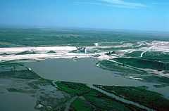
Optima Lake is a reservoir in Texas County, Oklahoma. The lake is located near the towns of Hardesty and Guymon in the Oklahoma Panhandle.
The earthen Optima Lake Dam (National ID # OK20510) was constructed in 1978 by the United States Army Corps of Engineers, with a height of 120 feet, and a length at its crest of 16,875 feet.[1] Although designed to contain a maximum of 618,500 acre-feet, the lake has never reached more than 5 percent of its design capacity,[2] and now is effectively empty. Rapid declines in streamflow (related to large-scale pumping from the High Plains Aquifer) coincided with the completion of dam construction[2] to make this lake a dramatic example of unanticipated environmental impacts.[3]
The US Army Corps of Engineers states (emphasis added):
Visitors should be aware that the lake's level can be very low. Depending on rainfall and evaporation rates, the lake may offer no water-based recreation and may not be suitable for swimming, fishing, boating or other activities.[4]
Lake camping facilities and buildings have been dismantled for public safety by the Corps of Engineers as of October 2012.
Notes
- ↑ http://ce-npdp-serv2.stanford.edu/DamDirectory/DamDetail.jsp?npdp_id=OK20510
- ↑ 2.0 2.1 Wahl, K & R. L. Tortorelli, 1996. "Changes in flow in the Beaver-North Canadian River Basin Upstream from Canton Lake, Western Oklahoma", USGS WRI 96-4304
- ↑
- ↑ U.S. Army Corps of Engineers Optima Lake website
References
- R. Lowitt, 2002. "Optima Dam: A Failed Effort to Irrigate the Oklahoma Panhandle", Agricultural History, 76(2):260-72
External links
- Oklahoma Water Resources Board Optima factsheet. The image on the first page shows the lake at its maximum level since dam construction
- 2006 Geological Society of America press release – Lessons to be learned from sites like Optima
- USGS online discharge data for inflow to reservoir (1937-1993)
- Optima Lake information on TravelOK.com Official travel and tourism website for the State of Oklahoma
- National Public Radio, 2013. "If You Want to Build a New Lake in Oklahoma, Forget History", NPR State Impact Oklahoma