Oodnadatta Track
| Oodnadatta Track South Australia | |
|---|---|
 | |
| Lake Eyre South from Oodnadatta Track | |
 NW end SE end | |
| Coordinates | 27°18′S 133°37′E / 27.300°S 133.617°E |
| General information | |
| Type | Track |
| Length | 620 km (385 mi) |
| Major junctions | |
| NW end |
Marla |
| SE end |
Birdsville Track, Marree |
| Location(s) | |
| Region | Kati Thanda-Lake Eyre National Park |
| Restrictions | |
| Fuel supply | Marla, Oodnadatta, William Creek, Marree |
| Facilities | airstrips, charters at all towns, UHF Radio repeaters with 100 km range on various channels provide emergency contact with locals. Swimming pools and police stations at Oodnadatta and Marla |
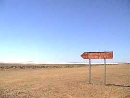
The Oodnadatta Track, Australia is an unsealed 620 km (385 mi) outback road between Marree and Marla via Oodnadatta in South Australia. Along the way, the track passes the southern lake of the Kati Thanda-Lake Eyre National Park, and the outback settlements of William Creek and Oodnadatta.
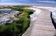
The track follows a traditional Aboriginal trading route. It provides travellers with stunning semi-desert scenery. Along the Track are numerous springs feeding water from the Great Artesian Basin, the most accessible examples being the mound springs found in Wabma Kadarbu Mound Springs Conservation Park near Coward Springs. Later, because of the availability of water, the route was chosen for the steam-train powered Central Australian Railway, the original route of The Ghan, also the route taken by the explorer John McDouall Stuart on his third expedition in 1859.[1] Remnants of the many railway sidings and bridges, the ruins of railway buildings, and Overland Telegraph repeater stations are located along the track - some of the best preserved are the Coward Springs Campground - complete with natural artesian spa and Curdimurka.
Today, the Oodnadatta Track roughly follows the former railway line as far north as Oodnadatta, and then turns to the west, meeting the sealed Stuart Highway at Marla. The road's surface is in great conditions right now - with road works on the road between William Creek and Oodnadatta. In dry weather, the track is passable to most 2 WD vehicles and caravans, but a four wheel drive (4x4) vehicle will provide a more comfortable journey, and will be essential for driving the track during and after rain. Since the track is unsealed make sure you check conditions here beforehand
The Track was named by Adam Plate of the Oodnadatta Progress Association Inc. in about 1980 to form a trilogy of unsealed tourist routes with the Birdsville and Strzelecki Tracks nearby.
See also
Australian Roads portal
References
- ↑ "Outback: The Oodnadatta Track". National Roads and Motorists' Association (NRMA). Retrieved 2008-06-24.
External links
- "Tracking History to Oodnadatta" by Roderick Eime