Ontario Highway 60
| ||||||||||
|---|---|---|---|---|---|---|---|---|---|---|
| Frank A. McDougall Parkway | ||||||||||
| Route information | ||||||||||
| Maintained by the Ministry of Transportation of Ontario | ||||||||||
| Length: | 255.8 km[1] (158.9 mi) | |||||||||
| Major junctions | ||||||||||
| West end: |
| |||||||||
|
| ||||||||||
| East end: |
| |||||||||
| Highway system | ||||||||||
<td width="100%" align=center" colspan="3" style="padding:0;vertical-align:middle;text-align:center">Current highways
| ||||||||||
King's Highway 60, commonly referred to as Highway 60, is a provincially maintained highway in the Canadian province of Ontario. The 255.8-kilometre (158.9 mi) highway serves as the primary corridor through Algonquin Provincial Park, where it is dedicated as the Frank McDougall Parkway. East of Algonquin Park, the route serves east–west traffic in the highlands of central Ontario. It begins at Highway 11 in Huntsville and ends at Highway 17 near Renfrew.
Highway 60 was designated in 1937 between Huntsville and Golden Lake. During the 1960s, the highway was extended east to Highway 17.
Route description
Highway 60 begins at an interchange with Highway 11 in Huntsville. It crosses through central Ontario in a generally east–west orientation. The triangle-shaped area bounded by Highways 11, 17 and 60 is largely uninhabited wilderness dotted with lakes and muskeg.
An Ontario Parks visitor's permit is not required to drive through Algonquin Park or access the Visitor's Centre. However, one is required for the use of any trails or similar facilities within the park boundary. Moose and deer are very common through Algonquin, especially at night and in the morning, and present a major driving hazard.[2]
Highway 60 exits the park in the Township of South Algonquin and carries on east intersecting with Highway 127. Beyond Highway 127, it passes through the Ottawa Valley, following the historic "Opeongo Line" to Barry's Bay and continuing through Golden Lake and Eganville until Renfrew where it ends at a junction with Highway 17.
A 4 km (2.5 mi) section of Highway 60, between Golden Lake and Eganville, is multiplexed with Highway 41.
History
Highway 60 was assumed on April 1, 1937, when the Department of Northern Development was amalgamated by the Department of Highways. At that time, Highway 60 ended in Lake Dore, north of Eganville and was 218.2 km (135.6 mi) long.[3] In 1976, the section through Algonquin Park was dedicated in honour of the 35 years of service by Frank Archibald MacDougall: ten years as park superintendent and 25 as Deputy Minister of Lands and Forests. It is referred to as the Frank MacDougall Parkway.[4]
-
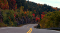
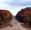
Highway 60 and Algonquin Park are renowned for their autumn display
-
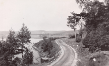
Highway 60 near Smoke Lake in Algonquin Park
-
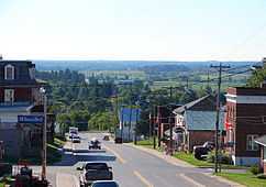
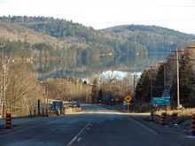
Highway 60 in Douglas
Major intersections
The following table lists the major junctions along Highway 60, as noted by the Ministry of Transportation of Ontario.[1]
| Division | Location | km[1] | mi | Destinations | Notes |
|---|---|---|---|---|---|
| Muskoka | Huntsville | 0.0 | 0.0 | Huntsville Bypass; Exit 223 | |
| 1.4 | 0.9 | Hanes Road | |||
| 2.5 | 1.6 | District Road 3 (Main Street) | |||
| 6.7 | 4.2 | District Road 23 (Canal Road) | |||
| Lake of Bays | 12.7 | 7.9 | District Road 8 (Limberlost Road) | ||
| Dwight | 23.6 | 14.7 | |||
| Nipissing | Algonquin Provincial Park | 43.6 | 27.1 | ||
| 58.4 | 36.3 | Smoke Lake Road | |||
| 91.7 | 57.0 | Opeongo Lake Road | |||
| 99.4 | 61.8 | ||||
| Whitney | 109.6 | 68.1 | |||
| Madawaska | 128.5 | 79.8 | Formerly Highway 523 | ||
| Renfrew | Barry's Bay | 156.3 | 97.1 | Beginning of Barry's Bay Connecting Link Agreement | |
| 156.8 | 97.4 | County Road 62 – Maynooth | Beginning of former Highway 62 south | ||
| 157.6 | 97.9 | Old Barry's Bay Road | End of Barry's Bay Connecting Link Agreement | ||
| Wilno | 166.9 | 103.7 | County Road 66 (Wilno Road South) | Polish Kashub Heritage Museum | |
| Killaloe | 180.9 | 112.4 | County Road 58 north (Round Lake Road) – Pembroke, Round Lake County Road 512 (Queen Street) – Killaloe, Brudenell | Formerly Highway 62 north; formerly Highway 512 south | |
| Golden Lake | 199.6 | 124.0 | County Road 30 (Lake Dore Road) – Germanicus County Road 70 (Kokomis Inamo) | ||
| Algona Wilberforce | 209.7 | 130.3 | Beginning of Highway 41 concurrency | ||
| Eganville | 212.8 | 132.2 | Beginning of Eganville Connecting Link Agreement | ||
| 213.6 | 132.7 | End of Highway 41 concurrency | |||
| 214.9 | 133.5 | End of Eganville Connecting Link Agreement | |||
| Admaston Bromley | 222.2 | 138.1 | County Road 8 east (Cobden Road) – Cobden County Road 9 north (Bulger Road) – Lake Dore | Westbound traffic must turn left to remain on Highway 60 | |
| Douglas | 229.7 | 142.7 | County Road 5 south (Stone Road) | ||
| Rosebank | 242.6 | 150.7 | County Road 61 south (Haley Road) | Former routing of Highway 17 | |
| Renfrew | 250.0 | 155.3 | Beginning of Renfrew Connecting Link Agreement | ||
| 255.1 | 158.5 | End of Renfrew Connecting Link Agreement | |||
| Horton | 255.8 | 158.9 | Trans-Canada Highway | ||
| 1.000 mi = 1.609 km; 1.000 km = 0.621 mi | |||||
References
- ↑ 1.0 1.1 1.2 Ministry of Transportation of Ontario (2004). "Annual Average Daily Traffic (AADT) counts". Government of Ontario. Retrieved February 26, 2010.
- ↑ Highway 60 Corridor Map
- ↑ Official Ontario Road Map. Department of Highways. 1938.
- ↑ "The Flying Superintendent’s Fairchild". The Country Connection, Winter/Spring 1999.
- ↑ http://www.algonquinpark.on.ca/visit/camping/west-gate.php
- ↑ http://www.algonquinpark.on.ca/visit/camping/east-gate.php
External links
![]() Media related to Highway 60 (Ontario) at Wikimedia Commons
Media related to Highway 60 (Ontario) at Wikimedia Commons
Route map: Bing
| ||||||||||||||||||||||||||