Ontario Highway 132
| ||||
|---|---|---|---|---|
| Route information | ||||
| Maintained by the Ministry of Transportation of Ontario | ||||
| Length: | 30.3 km[1] (18.8 mi) | |||
| Existed: | January 11, 1956[2] – present | |||
| Major junctions | ||||
| West end: |
| |||
| East end: |
| |||
| Highway system | ||||
| ||||
King's Highway 132, commonly referred to as Highway 132, is a provincially maintained highway the Canadian province of Ontario. Its western terminus is at Highway 41 near Dacre while its eastern terminus is at Highway 60 in Renfrew.
The length of Highway 132 is 30.3 km (18.8 mi). It is situated entirely in Renfrew County, travelling through the communities of Shamrock and Dacre. The road was built in the 1850s as part of the Opeongo and Ottawa Colonization Road, providing access to Renfrew County for settlement in the Opeongo Hills.
Route description
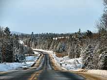
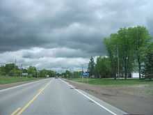
Highway 132 is a short connector highway that travels between Dacre and Renfrew, connecting Highway 41 with Highway 17 via Highway 60. The majority of the route travels through the Canadian Shield, with the exception of the final few kilometres approaching Renfrew, where it descends into the Ottawa Valley. Because of its rugged surroundings, there is relatively little human habitation along the route outside of the communities of Dacre and Shamrock.[3]
History
Highway 132 was assumed by the Department of Highways on January 11, 1956.[2] Prior to the designation of Highway 132, no other highways connected with Highway 17 between Pembroke, where it met Highway 62, and Arnprior, where it met Highway 29.[4] Although some minor realignments have occurred over the years, the route has more or less remained unchanged since its designation.[3]
Major intersections
The following table lists the major junctions along Highway 132, as noted by the Ministry of Transportation of Ontario.[1] The entire route is located in Renfrew County.[3]
| Location | km[1] | mi | Destinations | Notes | |
|---|---|---|---|---|---|
| Renfrew | 0.0 | 0.0 | |||
| Admaston Bromley | 5.7 | 3.5 | County Road 5 (Stone Road) | ||
| County Road 34 (Whelan Road) | |||||
| Dacre | 27.7 | 17.2 | Highway 513 may be decommissioned. It appears in Ministry documents but does not appear on any current maps, including the Official Ontario Road Map. | ||
| Bonnechere Valley | 30.3 | 18.8 | |||
| 1.000 mi = 1.609 km; 1.000 km = 0.621 mi | |||||
References
- ↑ 1.0 1.1 1.2 Ministry of Transportation of Ontario (2008). "Annual Average Daily Traffic (AADT) counts". Retrieved February 8, 2012.
- ↑ 2.0 2.1 "Appendix 3 - Schedule of Assumptions of Sections". Annual Report (Report). Department of Highways. March 31, 1956. p. 205.
- ↑ 3.0 3.1 3.2 Ontario Back Road Atlas (Map). Cartography by MapArt. Peter Heiler. 2010. p. 64. § P52–R55. ISBN 978-1-55198-226-7.
- ↑ Ontario Road Map (Map). Cartography by C.P. Robins. Ontario Department of Highways. 1956. § O38–P40.
External links
| ||||||||||||||||||||||||||