Omiš
| Omiš | |
|---|---|
| Municipality and town | |
 | |
 Omiš Location of Omiš in Croatia | |
 Omiš Location of Omiš in Split-Dalmatia County | |
| Coordinates: 43°26′N 16°41′E / 43.433°N 16.683°E | |
| Country |
|
| County | Split-Dalmatia County |
| Area | |
| • Total | 103 sq mi (266 km2) |
| Population (2011) | |
| • Total | 14,936 |
| Time zone | CET (UTC+1) |
| • Summer (DST) | CEST (UTC+2) |

Coordinates: 43°26′N 16°41′E / 43.433°N 16.683°E
Omiš (pronounced [ɔ̌miːʃ], Latin and Italian: Almissa) is a town and port in the Dalmatia region of Croatia, and is a municipality in the Split-Dalmatia County. The town is situated approximately 25 kilometres (16 miles) south-east of Croatia's second largest city, Split. Its location is where the emerald-green Cetina River[1] meets the Adriatic Sea (Croatian: Jadransko More). Omiš municipality has a population of 14,936[2] and its area is 266 square kilometres (103 sq mi).
Name
It is supposed that the name of this city, Omiš, developed from the Slavic Holm, Hum as a translation from the Illyrian - Greek word Onaion, Oneon, meaning "hill" or "place on the hill", but there is also the possibility that the name of the settlement Onaeum was derived from the name of the river which was called Nestos by the Greek colonists in its lower flow, during Antiquity.
Latin names during Ancient Rome were Onaeum, Oeneum, Alminium, and Almissum. During Medieval times the name was recorded as Olmissium, Almiyssium and from the end of the 15th century, when the city fell to the authority of Venetian Republic, its name was the Italian Almissa.[3]
History

Omiš was well known in the past by the Corsairs of Almissa (Omiški gusari)[4] whose Sagittas (ships) (Genitive case: Sagittae, translated as The Arrow), brought fame to them because they were built for attack and fast retrieval into the mouth of the Cetina River, protecting the town from foreign invaders. At a very early date, neighbours of the Corsairs of Almissa, the highlanders of the Poljica Principality [5] (Poljička Republika), became their friends and allies. This allowed them to harass the seaborne trade, without fear of a sudden attack from inland.
- Historical monuments:
- Church of St Euphemia by the coast on Brzet, from the early 6th century
- Mirabella Fortress (Peovica) from the 13th century
- Starigrad Fortress (Fortica) from the 15th century
- Renaissance church of the Holy Spirit from the 15th century
- Old cemetery, the 16th century or 17th century
- Parochial church from the 17th century
- Franciscan Monastery on Skalice from the 18th century

In the Priko neighborhood, on the right bank of the Cetina River, stands the site with the most historic significance: the pre-Romanesque Church of St. Peter (Crkva Sv. Petra) from the tenth century A.D. This single-naved edifice, with a cupola and apse, was used in the 18th century as a Glagolithic seminary for novice priests.
Economy
Today, Omiš's economy is based on farming, fishing, textile and food-processing industries and tourism.
Settlements
Within the limits of the town lie the following settlements:[2]
- Blato na Cetini, population 465
- Borak, population 158
- Čelina, population 222
- Čisla, population 302
- Donji Dolac, population 373
- Dubrava, population 300
- Gata, population 567
- Gornji Dolac, population 119
- Kostanje, population 605
- Kučiće, population 607
- Lokva Rogoznica, population 397
- Marušići, population 151
- Mimice, population 216
- Naklice, population 236
- Nova Sela, population 224
- Omiš, population 6,462
- Ostrvica, population 196
- Pisak, population 202
- Podašpilje, population 20
- Podgrađe, population 280
- Putišići, population 46
- Seoca, population 140
- Slime, population 270
- Smolonje, population 79
- Srijane, population 270
- Stanići, population 534
- Svinišće, population 98
- Trnbusi, population 162
- Tugare, population 885
- Zakučac, population 148
- Zvečanje, population 202
Tourist attractions
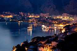
The Omiš Riviera stretches for twenty kilometers (12 miles) along a coast of exceptional beauty, with many perfect pebble, sandy beaches, bays, steep cliffs and a crystal clear sea. The mood is caught in an inscription on the lintel of a Renaissance palace in Omiš: "GRATIAS AGO TIBI DOMINE QUIA FUI IN HOC MUNDO" (Thanks be to Thee o Lord, that I have lived on this Earth). The destinations of Radmanove Mlinice and the Gubavica waterfalls (Velika and Mala Gubavica) are also points of interest. Radmanove Mlinice, located five kilometers (3.1 miles) up to the canyon of Cetina River, is an excursion/picnic place famous for bread baked under an iron lid (peka) and for fresh trout that can be caught from the river.
The Cetina River is a great place for those who like active holidays (white water rafting, canoeing and kayaking). Recreational activities, in Omiš, also include: free climbing, cycling, tennis, football (soccer), basketball, 9-pin bowling, bocce, paragliding, beach volleyball, windsurfing, water-skiing, sea kayaking, waterpolo and scuba diving.
Culture

Omiš is best known for the traditional klapa music festival - Festival of the Dalmatian a cappella singing groups.[6][7] This festival is the highlight of Omiš's summer, the expression of the town's beauty. Omiš's Summer Festival - during which various concerts and recitals are performed - takes place at the plazas and in churches.
- Omiš as a town has eight churches:
- church of Saint Michael
- church of Holy Ghost
- church of Saint Rock
- church of Saint Peter
- church of Saint Luca
- church of Saint Mary
- Franciscan Monastery with church of Our Lady of Carmel
- church of Saint Stephan and
- remains of church of Saint John in Borak.
- Other summertime cultural activities include:
- " Jure's poplars "
- " Fishing nights "
- " Swimming marathon "
- " Omiš triathlon "
- " Pirate nights "
- " Pirate battle "
- " Crazy dives "
International relations
Twin towns — Sister cities
Omiš is twinned with:
 Bol, Croatia
 Havířov, Czech Republic
- Nepomuk, Czech Republic
 Zagorje ob Savi, Slovenia
 San Felice del Molise, Italy
 Ryazan, Russian Federation
 Krupina, Slovakia
- Poprad, Slovakia
References
- ↑ Footprint Croatia By Jane Foster
- ↑ 2.0 2.1 "Population by Age and Sex, by Settlements, 2011 Census: Omiš". Census of Population, Households and Dwellings 2011. Zagreb: Croatian Bureau of Statistics. December 2012.
- ↑ "Povijest Grada Omiša" (in Croatian). Retrieved 8 April 2014.
- ↑ Frommer's Croatia with Your Family: From Idyllic Islands to Medieval Towns by Jos Simon
- ↑ The Late Medieval Balkans by John V. A. Fine Jr.
- ↑ Mediterranean Mosaic: Popular Music and Global Sounds by Goffredo Plastino
- ↑ www.fdk.hr/indexeng
Bibliography
- Cresswell, Peterjon; Atkins, Ismay; Dunn, Lily (10 July 2006). Time Out Croatia (First ed.). London, Berkeley & Toronto: Time Out Group Ltd & Ebury Publishing, Random House Ltd. 20 Vauxhall Bridge Road, London SV1V 2SA. ISBN 978-1-904978-70-1. Retrieved 10 March 2010.
External links
| Wikivoyage has a travel guide for Omiš. |
| Wikimedia Commons has media related to Omiš. |
| ||||||||||||
